
For three years, the famous Great Allegheny Passage (GAP) and the Chesapeake & Ohio (C&O) Canal Towpath have been on my radar. From Pittsburgh to Washington, D.C., hundreds of miles of car-free riding, I hemmed and hawed over planning my own bikepacking adventure. Go solo? Book a tour outfitter? Some hybrid? I spent an embarrassing amount of time deliberating.
Many cyclists who ride these two trails take Amtrak to either Pittsburgh or Washington, D.C., and then hop on the train again to return home. However, you must contend with Amtrak regularly running late. The week I was riding east from Pittsburgh, another Chicago-area rider and his son were riding from D.C. to Pittsburgh. Their train arrived in D.C. a full seven hours late. I’ve also heard horror stories about Amtrak conductors refusing to allow your bike on board, even with a reservation.
I finally pulled the trigger in January. Tour outfitters were out – the timing didn’t work, and they spent more days on the trail than I wanted to. I’m going to do my own trip.
I convinced Mitch to drive with me to Pittsburgh and take my car each day, meeting up at the next hotel. While I was biking, he could explore the region’s rich U.S. history, hike local trails, and indulge his love of trains. Since I was only carrying food, water, a rain jacket, and a lock, I could cover more ground each day than those riding self-contained.
Tale of Two Trails
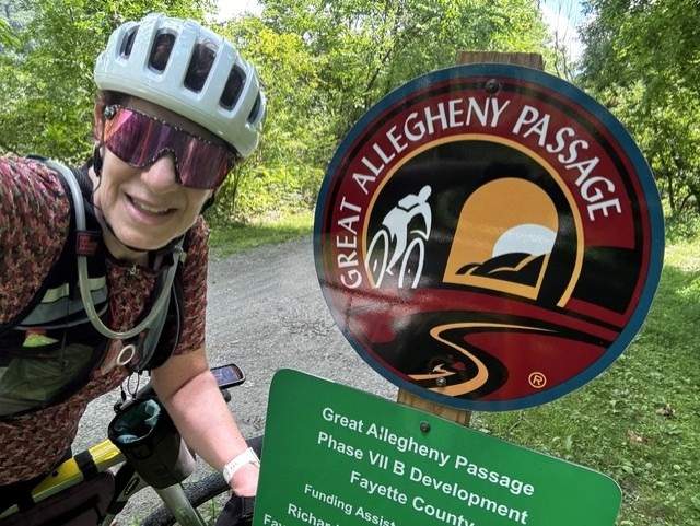
The GAP was completed in 2013 and is a 150-mile rails-to-trail from Pittsburgh, PA, to Cumberland, MD. The trail follows two rivers. First, the Monongahela River until it meets the Youghiogheny River in McKeesport. (Just past the town of Confluence is where the Youghiogheny and Casselman Rivers meet.)
Along the way, there are remnants of Pittsburgh’s past as a steel city, including a large industrial furnace, a ladle car, and a former steel mill. The former industrial towns along the GAP now provide food, housing, and services. Their proximity to the trail makes it easy for cyclists to access.
The GAP is primarily composed of crushed limestone and is in pristine condition. Volunteers monitor their section of the trail, keeping it free of downed trees, branches, holes, and trash. I cannot say enough about the fantastic job they do and the pride they take in the trail.
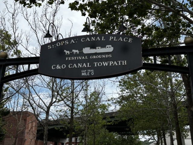
The C&O begins where the GAP ends at the confluence of Willis Creek and follows the Potomac River. The 184-mile path runs between Cumberland, MD, and Georgetown in Washington, D.C. Operating from 1831 until 1924, the canal had a 605-foot elevation change, thus requiring 74 locks, 11 aqueducts to cross major streams, and over 240 culverts to cross smaller streams. You can view many of the original features as you ride along the trail.
One of the highlights for trail riders is the Paw Paw Tunnel, about 25 miles outside Cumberland. It spans 3,118 feet, and you must walk your bike through it.
Unlike the GAP trail, the C&O is primarily dirt and gravel, with some crushed stone in sections. It’s not as well-maintained and is bumpy. I was happy to have 45 tubeless tires to absorb some of the bumps. Also, the section I was on didn’t have restaurants or other services, like bike shops, right on the trail. You had to go into town.
Day 0 – Monday, June 22
We drove eight hours from Chicago to Pittsburgh’s Oakland neighborhood, arriving around 3 pm at the Hotel Indigo, an IHG property on Technology Drive. It was pouring rain, though it was forecast to clear later that evening. I chose it for its location next to the trail. I highly recommend this hotel for its large rooms, filling breakfast, and ideal location. The only downside is the $22/night parking fee. If you have a vehicle, you’ll need to park elsewhere while on the trail.
After carb-loading at a local Italian restaurant, I prepped my bike and got to bed early.
Day 1 – Tuesday, June 23 – GAP Trail
Pittsburgh, PA to Ohiopyle, PA
74 miles, 1312 ft elevation
After a hearty breakfast at the hotel restaurant (included with the room), I rolled out of the hotel a little after 7 am. I had prepared GPS files before the trip, making it easier to navigate to/from the hotels and portions of the beginning of the trail.
The weather was perfect. Cool, partly cloudy, with a tailwind for the early miles. Today, the elevation gain was only 1,312 ft over 74 miles, but it was a steady climb for most of the day.

A block from the hotel, I crossed the Monongahela River using the historic Hot Metal Bridge. Built in 1887, over 15% of America’s steel-making capacity crossed over the bridge during World War II, up to 180 tons per hour.
I had to stop to take in the beauty of the Pittsburgh skyline and its many bridges, each more unique than the next.
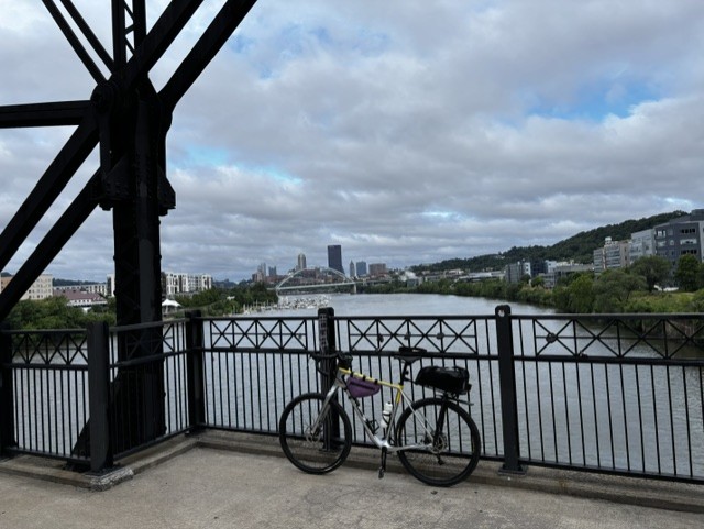
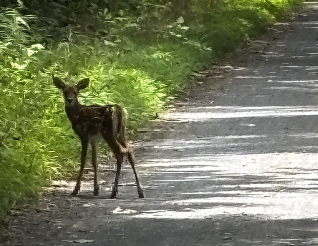
Once over the bridge, I crossed the street and onto the South Side Trail, which became the Great Allegheny Passage (GAP). This section was a paved multi-use trail, and I had to pay attention to GAP signage to avoid getting lost. I pedaled past the Steelers’ training facility and saw barges heading upstream, along with numerous white-tailed deer, rabbits, groundhogs, and birds.
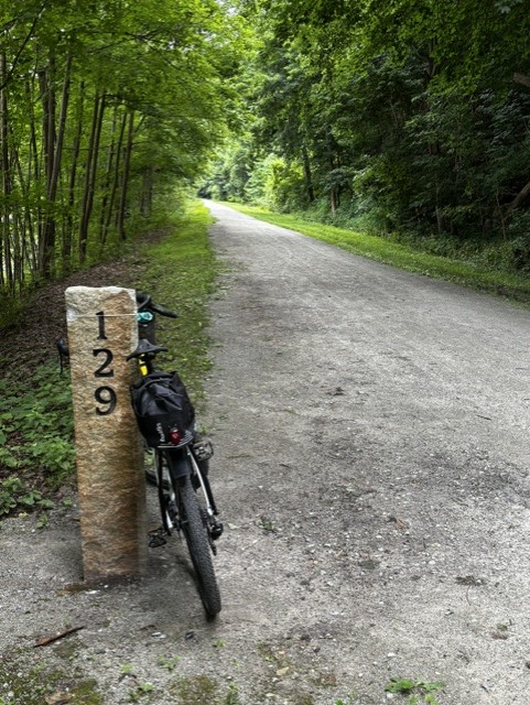
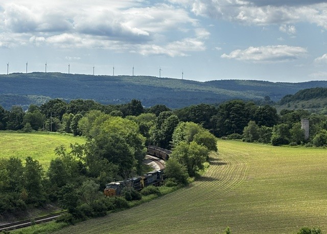
At around mile MM 130, the trail turned to crushed limestone. For the next 110 miles, I would enjoy the most pristine trail conditions I’ve ever experienced. As mentioned earlier, volunteers maintain the trail. I came across two downed trees over the 150 miles, and the fresh cut logs along the trail’s edge suggest this is a regular occurrence.
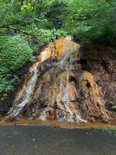
The beautiful, smooth trail allowed me to spend my time taking in the surroundings, which included the river on one side, dense forest and waterfalls on the other, and the occasional train paralleling the trail on the opposite bank.
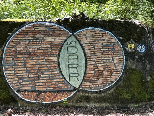
At MM 105.2, there’s an art installation dedicated to the Darr Mine disaster of December 19, 1907. The Darr coal mine explosion, one of the deadliest mining accidents in U.S. history, killed 239 men and boys, many of whom were Hungarian immigrant laborers. A long stone wall contains mosaic circles (made from remnants of the mine’s outbuildings) numbered 1 to 239, symbolizing each life lost. In the center is a large circle with the names of those who lost their lives. Without knowing the meaning behind the installation, the artist Rachel Sager still made an impact on me, prompting me to stop and reflect. Later in the day, when I got cell coverage, I read more about it.
I stopped at MM114 at the West Newton P&LE Train Station and Visitors Center. They have a 1914 railcar you can walk through, a gift shop with GAP memorabilia, and flush toilets. I met some locals at the center who were taking a break from riding and struck up a conversation with them. The older men like to share their knowledge and pride in the trail.
After 60 miles of riding, I was getting hungry for lunch as I approached Connellsville. I asked a couple of the volunteers responsible for maintaining a 23-mile section of the trail where I should eat. They sent me to The Kickstand Kitchen, a sandwich shop steps from the trail with a nice patio out back. The entire block had an array of restaurants to choose from, including sushi, Italian, and ramen bowls.
With a full belly, I made the final 12-mile climb to Ohiopyle, where we’d spend two nights at the Ohiopyle Suites. Don’t let the name fool you; it’s nothing fancy and a bit run-down. But it was clean and a block from the trail. Our suite had two bedrooms, a kitchen, and a living room.
I ran into Joe and his 9-year-old granddaughter on the trail earlier that day, and they rolled in as we were standing in the parking lot unloading the car. They were on day 4 of their ride and planned to complete both trails ending in Washington, D.C. What great memories those two will have for the rest of their lives.
Day 2 – Wednesday, June 24
Ohiopyle layover
Since there’s plenty to do in Ohiopyle and the surrounding area, we planned a layover day. The area boasts two Frank Lloyd Wright homes: Fallingwater and Kentuck Knob. If you prefer, there are 80+ miles of hiking trails, Laurel Caverns to explore, or white-water rafting.
We spent the day hiking the Cucumber Falls trail and touring the caverns. Dinner was at Twisted Spoke, which was around the corner from our hotel, followed by live music at the local community park.
Day 3 – Thursday, June 25 – GAP Trail
Ohiopyle, PA to Cumberland, MD
72 miles, 1,358 ft elevation
Today was another big mile day. 72 miles, to be exact. Wheels down at 7 am, the perfect time to spot a lot of wildlife on the trail. I had 48 miles uphill to reach the Eastern Continental Divide, followed by a 20-mile downhill into Cumberland and the end of the GAP trail.

In my opinion, this is the most picturesque section of the trip. The trail runs along the river, with cliffs and forest on one side and a working railroad on the opposite riverbank. Because of all the rain this area received, the forest was lush and sometimes obscured the view of the train, but you could still hear it. At times, it was fun to race the train, but I realized I was missing so much beautiful scenery, so I slowed down and took it all in.
Benches line the GAP, giving trail users a place to sit and enjoy the scenery. Many have an “in memory” message carved into them. Oddly, there was a bench facing the forest wall. But as I got closer, I was rewarded with a beautiful waterfall.
On the section from Ohiopyle to Meyersdale, I passed numerous waterfalls, crossed several bridges (viaducts), and went through several tunnels. Mountain Laurel, or rhododendron, was in bloom along the trail. I’ve been told conflicting information about which species it is, but it was pretty.
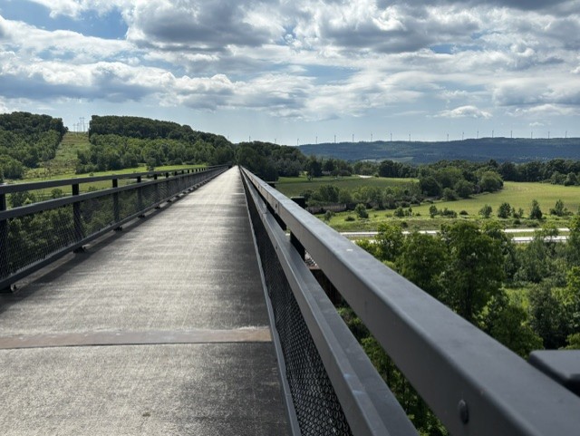
As I approached the Salisbury Viaduct, a chimney swift soared overhead. Earlier, I spotted a scarlet tanager. Both birds are new additions to my list. While I was taking pictures on the viaduct, a couple from West Virginia on eBikes stopped to chat. He is 82, and she is 76. They are so vibrant and full of life. They ride 20 miles out and back, sticking to their favorite sections. In their younger years, this couple rode the full length of the trail.
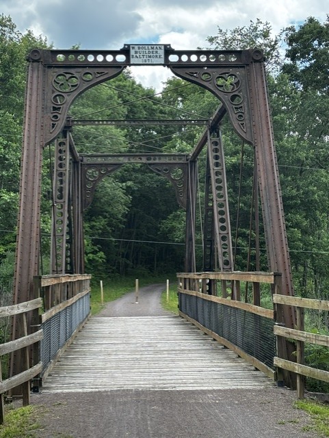
My lunch stop today was at the Meyersdale Depot and Visitors Center. The exhibits inside the building included model train layouts, historical artifacts, and a gift shop. Mitch used Garmin LiveTrack to pinpoint my location and timed his stop to coincide with mine. I grabbed a few things from the car to fuel me for the trip to Cumberland. Mitch decided to hike the trail to see the Bollman Bridge, built in 1871, and the Keystone Viaduct.
As I approached the Eastern Continental Divide, the trail turned to black cinder. Suddenly, a bear cub scurried off the trail and into the forest. I assure you, I did NOT stick around to see where momma bear was hiding, but I was excited to see the little guy.
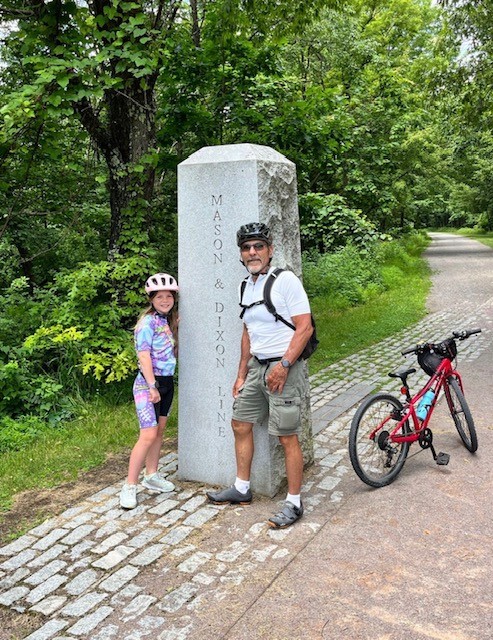
A short tunnel takes me across the Divide. Inside the tunnel is a topographical drawing showing the climb to the Divide and the descent into Cumberland. Then I cross the Masson Dixon Line and 20 miles of downhill!

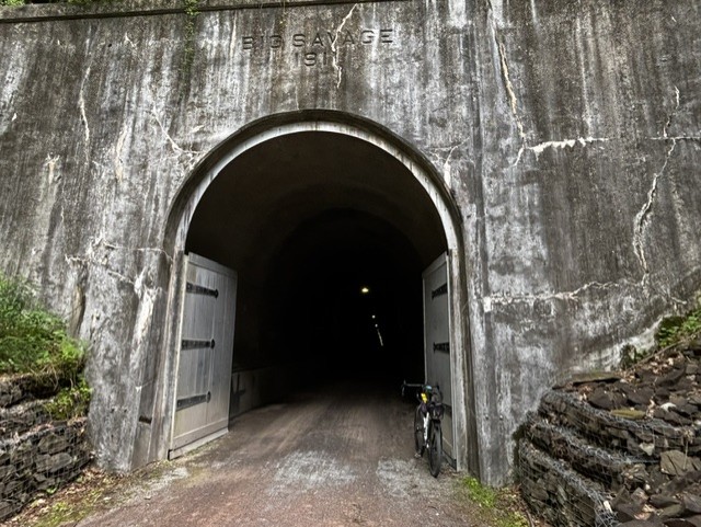
Next was the Big Salvage Tunnel, which is 3,394 ft long. In the picture below, you’ll notice doors at the entrance. The tunnel is closed from late November to early April to prevent damage from inclement weather.
After the Big Salvage tunnel lies the 957-foot Borden Tunnel, built in 1911 and passing through the Allegheny Mountains. As I pedaled through the tunnel, I was startled by the motion-detecting lights that turned on.
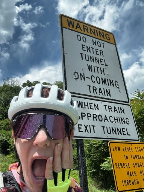
Continuing the descent around Frostburg, the trail runs alongside the Western Maryland Scenic Railway, an active line. I did not see a train, but before entering the 914-foot Brush Tunnel, warning signs alert you not to enter if a train is approaching.
Once in Cumberland, I made a quick stop at the National Park Service Visitors Center. They had a free brochure with facility details at each milepost along the C&O. Then I crossed MM 0 for the GAP and the start of the C&O. The hotel for the night was the Fairfield Inn, right on the trail. It was filled with bikers, including Joe and his granddaughter, who took two days to complete the Ohiopyle-to-Cumberland segment.
That evening, we walked to dinner at the Crabby Pig, where we ran into Joe and his granddaughter. They were fueling up for the longest leg of their trip, a 60-mile stretch from Cumberland to Hancock. After dinner, we enjoyed live music in the park behind the hotel and then called it an early night.
Day 4 – Friday, June 26 – C&O Towpath
Fort Frederick, MD to Harpers Ferry, WV
54 miles, 377 ft elevation
Today, I planned to ride 125 miles from Cumberland to Harpers Ferry. Based on reports, the trail conditions were not ideal, with rain overnight and thunderstorms predicted for the afternoon, so it was time to reevaluate the day’s plans.
Having a car allowed me to start anywhere along the trail, so I began at Fort Frederick State Park (MM112.4) and rode to Harpers Ferry, WV (MM60.8). Today it was relatively flat with only 377 feet of elevation gain over 54 miles. Most of the elevation gain came from climbing the mile out of town and the steep hill up to the hotel.

The weather was in the 80s, with high humidity. The gravel and dirt trail was riddled with potholes filled with water from the previous night’s rain. Unfortunately, I spent most of my time scanning the trail for holes and much less time enjoying the scenery. The area has been experiencing a lot of rain recently, causing mosquito and gnat populations to thrive. Stopping in any wooded area became a feeding frenzy for the bugs.
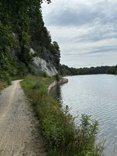
There were relics from the canal all along the Towpath. The scenery constantly changed from a dense wooded forest to cliffs on one side and the Potomac River on the other. Wildlife was abundant along the trail, including birds, deer, and turtles.
At Dam 5, there was the stairs-from-hell detour. For weeks, I read on Facebook about the detour and how treacherous the stairs were. At times, the stairs cause people and/or their bikes to fall. When I saw that I had to climb the stairs, I did a little dance. For me, it is easier to go up the stairs in cleats and with a rear-mounted rack than to go down. It’s especially “fun” when the stairs are even more slippery due to the previous night’s rain.
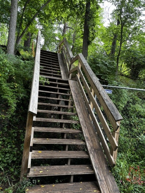
Honestly, it wasn’t too bad climbing the flight of stairs, and I continued to walk the bike through the cyclocross-on-steroids section until the detour continued along a street paralleling the path. A man going the opposite direction was pulling a long trailer, and I don’t envy the “fun” he’ll have taking it down the stairs.
Shortly after the detour, I came across a group of Mennonite women hauling butt down the trail. Strong women come in all sizes and backgrounds. Their bikes were fully loaded with gear; they wore traditional Mennonite dresses and bonnets; and their bikes were not light carbon-fiber like my Salsa Cutthroat. I stayed behind them for a while, then passed, not wanting to intrude.
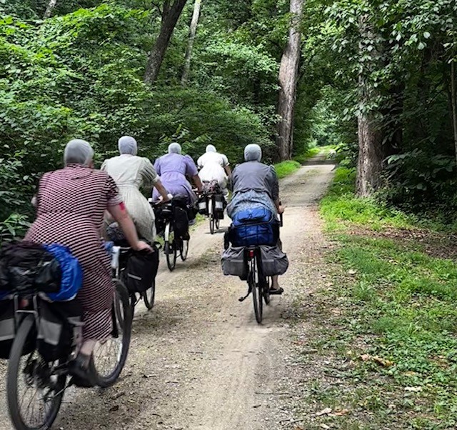
Up the trail, I pulled over to grab a snack and take some pictures. The group of women went flying past me. We continued to leapfrog for several miles. I posted my pictures from today’s ride to the C&O Facebook group, and several people said they had seen them at different spots along the trail. The group’s consensus was that the women were riding the entire trail.
One of the more beautiful sections of today’s ride was along the river’s edge. Tall cliffs were on the left, the Potomac on the right, and a narrow singletrack trail at times. It was a neat sight to see single riders dwarfed by the cliffs, peppering the landscape like dots moving along the horizon.
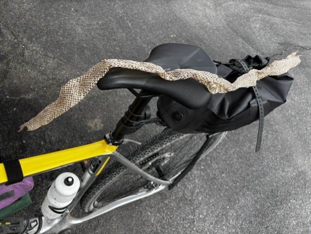
Shortly before arriving at Harpers Ferry, I came across the best trail find ever! Well, you might not think it is cool, but I do. A rat snake had just finished shedding its skin, and the skin had come off in one piece. It was a beautiful specimen lying in the middle of the trail. I scooped it up and brought it home. I only wish I had seen the snake, too.
Finally reaching Harpers Ferry, the end of my journey, I found the trail under construction. To get to town, I had to haul my bike up several flights of metal stairs, cross the river, and descend the other side. My hotel was another mile away, literally up the road, with the final climb at over 8% grade. All I could think was that I’m glad I didn’t ride 125 miles today.
Final Thoughts:
Traveling along the GAP/C&O there’s so much history and beauty to explore. Ideally, if your schedule allows, keep your daily mileage to 30-40 miles. A slower pace allows you to take the time to stop and explore. I rode the GAP in two days, but I still spent eight hours on the trail each day. I would talk to the locals, absorb the history, and take in all the beauty Mother Nature had on display each day.
Throughout the trip, I was blessed to meet so many wonderful and adventurous people. Some I met briefly, others I rode with for several miles. I only wish that I had more time to complete the C&O trail, too. But there’s always next year.
No matter which flavor you choose to ride these iconic trails: self-contained, with a tour operator, or a hybrid, you can’t help but have an amazing time.
Resources
Facebook Groups:
– Great Allegheny Passage / C&O Canal Enthusiasts
– C & O Canal & Great Allegheny Passage (The Gap) Biking Adventures
Gear Used
Salsa Cutthroat
Tailfin Journey Rack – Used this Tailfin rack because of the fender, folds up when traveling by car, and removable top bag – review coming soon.
Tailfin removable CargoPack rear rack bag – Review coming soon
Garmin Edge 1040 Solar Cycling Computer
Panaracer Gravelking X1 Plus + 45c
SaltStick Tablets and FastChews
Showers Pass New Century Jacket
Sheri Rosenbaum regularly contributes articles and reviews products for RBR. She’s an avid recreational roadie who lives in the Chicago area and a major advocate for women’s cycling, serving on the board of directors and volunteering with the Dare2tri Paratriathlon Club. Click to read Sheri’s full bio or visit her web site sunflowersandpedals.com.
Next Article: Is testosterone replacement therapy acceptable for recreational cycling?
Leave a Reply