Trying to decide which app to use on your next bike ride? As a cyclist, it’s easy to be overwhelmed by the large number of cycling apps available for Android and Apple phones. New apps are published every day. Some of them are made for general activity tracking that cover multiple sports, while others are specifically made for cycling.
For cycling, the top apps that are most popular and (we believe) most useful for cyclists are Strava, MapMyRide, and RideWithGPS. Their popularity is already at a high level which means you can also connect with other users and the communities around the apps. While all three apps aim to deliver the same tracking purpose, their functionality is somewhat different. In many cases, it is not a matter of which app is the best, but a case of which app suits your needs.
Strava
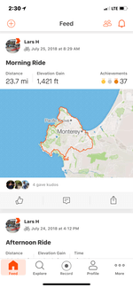
Strava is probably the most popular cycling app. Not just for cyclists, it’s also very popular with other athletes such as runners. Probably the best aspect of Strava is that it’s also a robust social network and not just a mileage tracker or mapping app.
Free Version Vs Paid Version
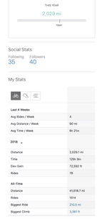
Strava is available both in a free version and in a paid version. Most cyclists are fine with the free version, which offers plenty of great features. The free version allows you to access or customize information about your heart rate, your route, and even your gear. When you finish recording a ride, you can always go back to it to check your cycling pace or to see the information on the elevation of the route.
The paid version offers a more detailed perspective on your cycling experience. Previously called Strava Premium, it has been reorganized and renamed Strava Summit. Instead of just a single premium choice, you can pick and choose which features you want to pay for or get them all.
There’s the full Summit Pack, which is the same price as the old Premium account. For $5 a month, billed annually at $60, you can get all the features of the Training Pack, Safety Pack and Analysis Pack. But if you don’t need everything, you can also pick and choose from the other packs which cost just $2 per month, billed annually.
One of the best parts about Strava is the feature that allows users to create “segments” on the route. You can see how you performed in a certain area unlike with the free version which shows you the details as a whole. At the same time, you can use this targeted information to improve your own results by comparing your time with the time of other cyclists on the same route. However, this functionality is limited by the number of cyclists who are actually on the same route as you and it might not be the best solution when you cycle in remote locations.
Progress goals can also be an interesting feature. Cyclists can use it to set certain times or certain results they want to reach. When you try to improve your own personal records, you can use this functionality to set a time you want to beat on a certain track.
Suffer Score is a functionality which integrates your heart rate and which is available in the paid version. The harder your bike ride measures, the higher the score. In a long-term perspective, this can be useful if you want to improve your cardiovascular endurance or just see how hard that last ride really was.
Also available in the paid version, the Leaderboard Information is a great tool to see how you compare against other cyclists. You can see their time in certain areas of your route and you can share your time as well. Other functions include the possibility to see who is active on the route, but this is still a feature available in the paid version. You can also filter by age and weight.
Privacy Settings
Strava records your routes and shares them publicly unless you set your rides to private or hidden. For cyclists who are using the same routes from home to work, this can quickly become an issue. There are a few steps you can take to improve privacy if you like the app. For example, you can use the small feature of the app which allows you to work with Privacy Zones. These zones do not show your home point as a start location for your route and they use a nearby point for safety purposes. Even if limited in efficiency, it can still be a good solution for some privacy. Here’s an article we wrote that shows you how to hide the exact location of your home or workplace.
Pros
- Works with most GPS bike computers like Garmin, Wahoo.
- Works as an app on your iPhone or Android phone or Apple Watch.
- Available in free and paid versions
- Tracks cycling routes
- Records heart rate information
- Works with a power meter
- Indicates elevation details
- Shows detailed speed information
- Allows you to connect with other cyclists and also control who you connect with
- Progress goal tracking capability
- Comes with heat map for popular streets
Cons
- More detailed ride analysis Information only available with the paid version
MapMyRide
MapMyRide is another easy to use app that is one of the most popular ones for cyclists. It also lets you connect with your friends and to compare your own tracking results. MapMyRide is owned by Under Armour.
Connectivity
But as with any large application, it also comes with connectivity options with other apps. For example, you can connect it to MyFitnessPal for a more professional approach to nutrition. You can connect the app to a heart rate monitor to have a better idea on your own cardiovascular health.
But the app can be connected to certain devices as well. There are many devices which can synchronize with the app and one of the most popular is the FitBit tracker. Whitings devices such as trackers and scales can also be connected to the app. Inputting and exporting data is easy as well. You can easily input your own favorite rides in files such as .TCX (Garmin-specific files) and .JPX files.
Free Vs. Paid Versions
For most cyclists, the app is great in its free version. It allows basic tracking which is enough to cover the needs of most users. The free version allows personal goal tracking, lifetime stats, and unlimited mapped routes among others. The paid version removes all the ads from the app. But it also comes with extra features such as unlimited printed maps, cadence analysis, live tracking etc.
The free version is a good place to start and it is easy to use. Browsing between the speed information, and elevation information is easy. You also get a graphic representation of your route on a map.
Pros
- Clean modern design
- Made with unlimited mapped routes
- Free lifetime statistics
- Connectivity with major apps such as MyFitnessPal
- Personal goal tracking
- Ability to connect to a heart rate monitor
- Connected with social media
Cons
- Live tracking only available in the paid version
- Ads on the free version
RideWithGPS
With thousands of users every day, RideWithGPS is one of the most popular solutions for cyclists. The app has two main modes. One mode uses a map which you can interactively use to draw your own route. A second mode is a search tool which allows you to find routes according to specifics such as distance or elevation. Your map can be loaded on various devices and you are then ready to cycle.
Browser Customization
RideWithGPS is browser-based. You can create your own custom route on the official website and you can have one of the best solutions when it comes to the ultimate customization options, especially on desktops. The app can also be used on smartphones.
The route can be saved in various files such as .TCX and .GPX to be uploaded to devices such as those from the Garmin line. Additional information can also be added to the routes. They can include gear info such as the type of bike you are using but they can also be various photos of the route or the gear as well.
Fitness options are also included in the app. You can add various heart rate Zones which let you estimate the type of effort you will encounter. Entering your own details, you can also estimate the number of calories you are going to burn, which is important if you are using cycling as a solution to losing weight.
Free vs Paid Versions
The basic version of RideWithGPS can be enough for most cyclists. It comes with a detailed activity center which is a great tool to use when it comes to weekly or monthly schedules. You can also maintain a cycling regime from the activity center through the year.
The free version also offers interesting gear functionality. You can keep track of the certain miles you have with your bike or bikes which can be helpful to assess their durability. The free version also offers you the ability to have phone support if needed.
The premium paid version goes into detail. As most other paid apps, it offers you the ability to track split time. If you want to focus on interval training, the feature can be recommended. With extra fitness functionalities, the paid version can be recommended if you need to improve your physical shape. You can keep track of your body fat, weight and hydration levels. The paid version also allows you full access to all the premium features which might be released in the future by RideWithGPS.
Limitations
The biggest limitation of RideWithGPS is that it comes from a desktop browser version to a smartphone app which seems complicated at the time. It is why so many users actually complain about the problems they experience with functionality. Offline navigation is also limited by the package you have which includes free, basic and premium subscription. Some users also complain that there is no undo functionality when you accidentally delete a route, even in the premium version.
Pros
- Detailed routes straight on the map
- Search functionality for routes in your area
- Works in browsers and in the app
- Synchronizes with Garmin GPS devices
- Tracks cycled miles with certain gear
- Works with the search function to find routes
- Health and fitness functions
- Comes with phone support
Cons
- Split time available in paid versions
- Direct write to Garmin devices only available in paid versions
- Difficult to handle for some cyclists
Which App to Choose?
RideWithGPS is the favorite app for many cyclists who like the mapping features. It is complex and it has plenty of great functionalities. But it lacks the user experience to make it a solution which can easily be used by most cyclists.
Strava and MapMyRide are two of the most popular options on the market. They have an impressive user database which makes them a good choice when you want to meet other cyclists.
For example, Strava comes with the ability to compare your own results in certain routes or route segments with other cyclists. With a growing number of users, it can prove helpful for many people who want to see the best results in skill improvement. The system with digital badges can be helpful as well. You can set your own objectives and try to meet them all. The better you are at meeting these objectives, the more digital badges you will have.
The time comparison functionality is also available in MapMyRide. But instead of simply showing the best times, the app also takes into consideration the number of times the cyclists have been on the route. It makes sense for cyclists who are familiar with the route to have the best times. But then again, other cyclists prefer a simple ranking based on time.
In terms of user experience, the apps can be similar. But they do come with their own characteristics. One of them is the number of steps you need to take in order to be able to record your route. In Strava, this can be done instantly. In MapMyRide, you need to make two presses to start recording. Users also report that Strava is the friendliest app for battery life.
The premium versions of both apps are quite strong. The premium Strava app comes with no ads, live tracking, filtered leaderboards, cycling training plans and fitness analysis. The premium MapMyRide version comes with various goals you can set, exportable routes and the ability to filter leaderboards.
In terms of overall simplicity, Strava can be considered a great solution for many cyclists. It is easy to use and with graphics which are user-oriented, the app looks great as well. It’s also true that the app already has many of your cycling friends on it as well. In many cases, it means you have the ability to share your experience with your friends. Since it has so many users, Strava can also choose the best route for you as it has complex information on elevation. It can give you flat routes if you are looking for the path of least resistance.
But if you only seek the best graphs for elevation data, RideWithGPS can be a good option as well. The app also comes with a replay function which can prove useful in some situations. In the end, the final call is up to you. Since you want to spend more time on the bike and less time behind a screen, the app which is best for you is the one which is intuitive to use.
I have tried both Strava and RidewithGPS and consistently got very frustrated at how difficult it is to get basic metrics off of a Strava ride.
I’m not sure how you missed it but you can create your own Segments in RidewithGPS and if you are a paid member you can have private Segments. From these you can easily see how fast you did any given section of a ride and compare with your own previous rides and with others. Plus you can easily compare you and/or others in as many rides within a segment and break it down into quarters, thirds, or in half to see how you performed in any segment of a Segment. You want to see where you were fastest? Done, Fastest cadence? Done, Compare the grade with your cadence? Done, Compare speed or heart rate with grade? Done.
If any of this is possible in Strava I’ve yet to figure it out.
Let me add that RidewithGPS’s staff is amazing in responding to questions or problems.
Thanks for your comment! I’m a Strava user, mostly because I have been using it for so long and already have all my rides recorded there.
You make some interesting points. Thank you for letting me know about the segments. I’ll update that.
I prefer Map-My-Ride which also has a easy to use Create Route option.
Editing existing routes is also pretty easy.
Then I use https://www.fitnesssyncer.com/ to auto copy my routes to Strava and can have a presence in both.
Fitnesssyncer will copy about any data to any other popular app.
Except apps like WalkerTracker which refuses to let FS sync with them!
My club is very happy with Ride With GPS. We are much more into the “smile scale” than the “suffer scale”. and we are able to easily create maps and cue sheets for our rides. Last summer, I downloaded the gpx track for EuroVelo 6, converted it into a RWGPS Route, and then used it to ride across France with my iPhone giving me directions all the way.
That sounds great. Did it give you voice directions?
So what what is the easiest way to get route from ridewithgps to wahoo computer? Is that even possoble?
It’s very easy with strava and wahoo
RideWithGPS has a support page that explains how to get the data over to your Wahoo here: https://ridewithgps.com/help/wahoo-elemnt
was using free MMR for the past 5 years. due to many bugs recently changed to strava.
MMR announced every kilo meter, current speed, average speed and total distance covered.
these announcements prompted us to improve accordingly.
are these facilities available in strava
Map my ride will NOT let you see a list of rides created by a specific user.
Therefore it was impossible for our club to see the list of rides we have created on the mapmyride site.
Also, map display recently changed in MapMyRide that really diminished the usefulness.
For 2020 we are changing to RidewithGPS.
We didn’t use Strava because it doesn’t recognize bike path sections of rides. Not useful at all to leave these off the strava maps,
Thanks for your comment!
I use the Ride With GPS and i love it. but i have an issue with the Live Tacking
I downloaded it but not sure how to auto copy to Strava
That sounds great. Did it give you voice directions?
Yes, RwGPS can play audio cues. Those are automatically synthesized from properties / text of cues that you set when you planned the route (cues are also automatically added when you plot route via “follow roads” tool).
Big problem with Strava is awfully outdated map. I am pretty sure that Strava maps for my local area are more than 3 years old. This is ridiculous. Big chunks of new roads and trails are missing!
Since OpenStreetMaps (base for MapBox and Strava) is filled pretty quickly – Strava maps looks very blank compared to actual state. This probably does matter much for road cyclists which rides same paved routes over and over again. However, if you are all about off road and secret trails – well, you are out of luck.
And its route planner is very basic to say the least.
Overall, Strava is more about “push the record button and put phone in your pocket” approach.
RwGPS is superb when it comes to maps and routing. I have tried a lot of fitness trackers apps and RwGPS was the top. Several map sources, offline maps – those are main advantages. I was sold immediately. Sure, its premium is above average for fitness trackers, but it is well worth it.
RwGPS supports auto export to Strava, so you can use RwGPS on your phone during rides, and use Strava as social platform. And there is always an option to use something like Tapiriik to sync/export RwGPS to even more platforms.
There are many more minor bonuses of RwGPS – such as barometric elevation support, sharing private rides via URLs, exporting someone’s else rides without need to pay for premium, horizontal screen orientation (for handlebars), etc.
However, as good as RwGPS is – I still occasionally use OsmAnd as a backup for mapping, since RwGPS is still not that powerfull. For example, OsmAnd allows me to use Google as background, while showing map from OSM on top and use Strava heatmap as overlay – such combination was prepared with SAS Planet. This is great if you get yourself in the unmapped woods in unfamiliar area.
I am currently planning a bike trip from Rhode island to Kentucky and am primarily looking for the best navigation tool.
What would you recommend and why?
Thanks.
For planning a xcountry trip I would use either Ridewithgps or the Garmin mapping app. Why? The Garmin mapping app files will work with your Garmin (I am only guessing you have a Garmin) the best never having a navigation failure.
Ridewithgps on the other hand as an extensive number of maps you can switch to. That is great but it can also be problematic if you for instance use the Topo map to find some dirt shortcut someone told you about and forget to switch back to the regular map. Then you might find yourself on overgrown logging roads that have not been maintained in years. Yep – I’ve done that and even googlemap can get you. Solution – try to always check secondary and tertiary roads with the google street view so you know it is a real road.
Thanks for your comments Mike. Bottom line then: Garmin ( which I currently don’t have.)
Lately I’ve been having trouble with Map My Ride regarding the distance ridden. I generally use two meters: May My Ride and a Bontrager (40W) cyclometer. Until a month ago, the MMR was always the longer distance. Then something changed. Now the meter is giving the longer ride. MMR doesn’t have an answer for me. Same ride, shorter distance.
I tried a one time experiment of using MMR, Strava and the cyclometer. There was nearly a mile difference between the two GPS apps with the cyclometer and Strava being much closer. I know they won’t be exact, but a mile difference is too much for my thinking.
If you want exact data – just use a speed sensor. Connect it either to your cyclometer or phone’s app (just don’t use Strava, AFAIK – it ignores speed sensors, only cadence is recorded). Assuming you have properly calibrate/set it up – you will get much better results than GPS alone. GPS is not precise, and the difference that you see is app’s heuristic smoothing of the path.
For example, take your phone and record ride with 2-3 different apps. The results will be different! Even though both apps have used exactly the same GPS hardware.
Thanks! I appreciate your comment.
How can I set my Strava app to give me voice directions when I am following a map.?
Hello. Does anyone know if a person can use 2 of these apps at the same time to help in making a decision? For example, could I use both Strava and Map My Ride at the same time (on the same ride) and compare the experience? I’m kind of new to all this and appreciate any info provided. Thanks!
Sure, you can.
If your phone is not too old, and can physically run several trackers at the same time (and have enough RAM) – no problem at all. You can run 10 apps, if you want to.
Even battery life may be not affected that much, as most power is consumed by GPS – which is shared between apps. You may see the difference in battery life if one app updates positions each 10 seconds, while another app updates each second.
Thank you. I appreciate your response and information.
I don’t know about the other apps but with RWGPS I can use it with a phone that has no data or phone service.
The app and the gps functions need no data connection.. It lets me use an old phone or a cheap Tracfone phone and not risk theft or damage to your primary smart phone with photos and contacts and prefered configurations. When you return home, your ride data will automatically upload to your account if it’s open on your pc.
Don’t know if the other apps will function this way.
Strava ripped its heart out last year by no longer supporting connecting HR monitors via bluetooth. That was a deal breaker for me to I switched to the Premium version of MMR.
Has anyone used a Fitbit Versa together with RwGPS to capture heart rate and calories burned?
Wondering the same a year later!
I don’t believe RwGPS connects to Fitbit. Just Garmin.
I tried to sign up to MMR but it refuses to let me. Tried several times. What a waste of time. Strange as I’m already registered with Under Armor shopping.
Oh, got it to work now, was my browser acting funny I think.
The biggest problem for me with Strava is the poor quality of the mapping data. I am an urban rider, and their maps do not show whether or not a street is one-way, for instance. Can’t tell you how many times I created a great route that I couldn’t actually ride because of this. Their maps are taken from OpenStreetMap, which does show one-way streets, so I’m not sure why Strava doesn’t have that basic information for a major city. Ride with GPS does show directions, fortunately.
User of an Android mobile, one of the latest. I have for almost 2 years used Fit / google maps for free (the app has crashed about 4 times within that period) and then for a little over a year because it became a bit boring to only use FIT / google, used Strava`s app and “Naviki” free version to track my bike rides and walks every single day as it’s all I do in … Let me put it this way, strava hits the right route and km for every approx. 17 bike / walk trips I have and I have reported it every single time to strava, even some of the real results the strava app has registered, I have reported in to them, because strava might be able to see what it is that goes wrong so often ..; (
I found out that there are many people who get wrong results from the strava`app, but due to the social, use them with the free version, still strava; (
Naviki is also quite a capable gps tracker, but the design lags far behind, unfortunately .
I heard MMR no longer supports trip computers or sensors. Is this true?
As a long time user of both Ridewithgps and Strava which both sync back to my Garmin I have just decided to come off Strava. I’m a pleasure cyclist, not fast, not interested in my section times (let’s face it I’ll never be a contender) I just cycle for pleasure. Like, take the train and cycle 100km home. R.W.G. (especially the desktop version) is BRILLIANT for routing. STRAVA and GARMIN are RUBBISH.
I shall miss the Social Side of Strava (maybe), but Garmin gives me all the tech specs I might need. R.W.G. wins for Routing, Pictures, Reports and Stories. I hope to do a LEJOG and can see others who have planned the same, read their stories, see their photos and easily import their routes into mine. Something impossible with STRAVA. – STRAVA for Fitness Freaks, R.W.G. for people who want to cycle for pleasure.
Just so you know about another, I have been using Walkmeter for years. I simply indicate that I am on a bike. it gives me all the basic information I need. I can edit the data to account for unusual circumstances, send to my calendars, add notes regarding weather, or what I intended to accomplish on the ride. It compares one ride to another on the same route. Can save unlimited routes. No fees or charge. Handy for walking / hiking as well. I use both ride with GPS and Walkmeter and find the later simpler and easier to use.
In your cons for Map My Ride, you neglected to mention Under Armor’s data breach several years ago. That should be a factor when choosing to use an app trusted with so much personal data — is the company behind it taking security seriously?
https://www.reuters.com/article/us-under-armour-databreach-idUSKBN1H532W
I might have missed something, but do any of the apps show types of paths, for example; riding on roads with just a painted lane, bike only, shared lanes? Thanks
I don’t believe any of the App above show this. Most/All will show Sat Images however which I use when planning a route through a town / city.
Thanks. I’m having a hard time finding safe routes frequently in the DMV the bicycle routes just end on streets with 40+ mph speed limits and no shoulder or sidewalk to switch to. I will keep looking. I appreciate the reply.
None of these reviews mention the extraordinary amount of personal data scraped off your device by these developers. Under Armour’s privacy statement is downright scary, logging personal heath data, non-UA products you purchase, They then pass your data to 13 categories of analytics firms — too many to list, they say — that use your data “for their own purposes.” There’s no way to opt out at all on Map My Ride Read Under Armour’s privacy policy and check out Wired’s “How to Manage Your Privacy on Fitness Apps.”
In addition to knowing where your live, and where your ride, it’s constant vital signs monitor with notes by your personal trainer, passed to corporate America to enrich their personal health and financial dossiers on you. Doctors are prohibited under HIPPA laws from relinquishing health data. Under Armour and the others simply take it from their apps and linked fitness trackers, then spread it around. Who’s to say it couldn’t impact your health insurance rates or be seen by a prospective employer? It’s not paranoia, it’s happening now.
FYI, all – You can now connect RwGPS to STRAVA using the CONNECTED SERVICES function on the web version of RwGPS. This is found only when you EDIT your Profile.
Using Ride w/ GPS.
Can I create a bike route with turn-by-turn data, then download it to my Android phone, and receive turn-by-turn guidance visually on my phone’s screen and audibly in my blue tooth earbuds?
“create a bike route with turn-by-turn data” – yes
“download it to my Android phone” – yes
“receive turn-by-turn guidance” – not on a free account, it is for paid subscription only
Thank you – that’s a big ‘help’.
Just completed multi day with RideWithGPS. I appreciated the ability to change route map on the fly while we were riding – we encountered too much road traffic and wanted to shift to another route. The integration with Garmin radar was tremendous and indespensible. You might find a route going opposite direction and could turn off the voice nsv snfd follow. We could share trip reports with integrated photos. One does need to keep eyes wide open to avoid getting lost in the interface. Stiil I have been happy with the platform. I have been using paid version.
Ride with GPS is my go to app. RideWithGPS and an old phone (no SIM needed) make for a very inexpensive bike computer. Has Bluetooth interface for cadence if desired. I use a RokForm case and love it.
Create maps on a computer and download for off line use and get turn by turn. Also worked well with trips we did in Greece, Spain and Italy. The tour provider sent us links to his daily routes, we down loaded them before the trip to get a visual of the ease or intensity of the daily routes and we were able to ride on our own for the most part.
No sim card required if using offline rides just need GPS. Has Blue tooth interface for cadence if wanted.
Ive been riding with Strava (paid) and Ride with GPS in Spain.
Strava after a few hours would keep losing the GPS position and stop drawing the route. It randomly restart, and draw a straight line to fill the gap – losing mileage etc.
Whereas RWG was fine?
Also noticed that the RWG route is much more accurate and detailed.
I tried following Strava automated support to reset the GPS location etc. But it didn’t work.
Anyone else had these issues?
I started with Map My Walk. When I started riding a Recumbent Trike, I added Map My Ride..
Then, I switched to Strava, as it had walk and ride (and others) in one app.
I do not like GPS speed tracking.
I wanted to add a speed sensor to Strava. It only supports heart rate. I do have a paid version and was using a Moofit chest strap.
So, Ride with GPS supports many sensors (speed, cadence, heart). It doesn’t support my Moofit.
Yesterday, I bought both Wahoo speed and heart sensors. Interstingly, the heart rate strap seems to support cadence. I imagine that uses a pedometer-like “bounce counter” when running and may not provide riding cadence. I only need heart and speed.
So… Strava has the social component. I’m thinking to use the free version of RwGPS, and sync it with Strava for the social connections.
Opinions?
Hi. It’s great to see this thread is still alive and well! I came off everything and just had RWG but like you, missed the social side. I use Garmin sensors etc so went with the Garmin Connect to sync everything up. This all works well now as I have bought a Garmin Watch also. There are a couple of programs around to sync data with various programs – RunGap for Apple and FitnessSyncer for Android but I don’t use them. I must admit, that since I bought my watch, then the “My Day” in Garmin Connect gives me all I want to know about my health. But then, I not a serious racer, just a happy cyclist. We all have different needs! 🙂