
Tunnel Hill State Trail: An Ideal Fall Vacation

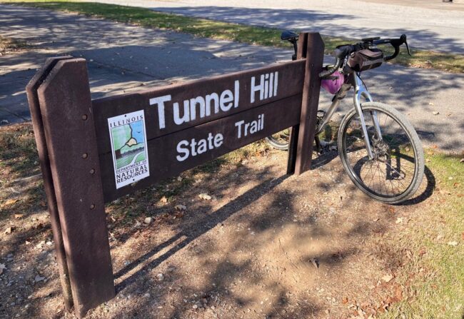
The autumn weather in the Chicagoland area has been unseasonably mild. I was riding in short sleeves and shorts through most of October. Craving one last adventure before the end of the year, I started tracking the fall foliage maps and trying to predict when the leaves would peak in southern Illinois.
The Tunnel Hill State Trail has been on my radar ever since Ride Illinois hosted a webinar about it a few years back. Located in southern Illinois, only 5 ½ hours from Chicagoland, the Tunnel Hill State Trail goes through Shawnee National Forest. Hmmm, biking and hiking in the same area? I needed to get myself down there.
Trail History
Located in Southern Illinois, this rail-to-trail follows the former Cairo and Vincennes Railroad, completed in 1874, which hauled coal from southern Illinois mines, along with produce, timber, and passengers. Over the years, the railroad went through a series of ownership changes, and the tracks last belonged to Norfolk Southern Railroad, which turned the corridor over to the state in 1991. The first sections of trail opened in 1998.
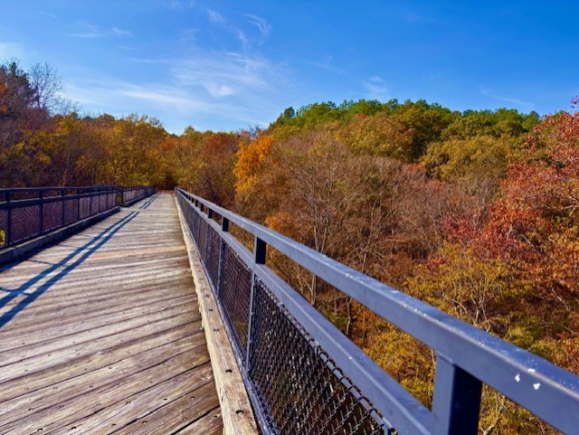
The trail boasts a tunnel and two dozen trestles that cross streams and rocky ravines. The trail is 52 miles long and travels through forests, wetlands, farmlands, and towns in the rural countryside.

Last Minute Planning
Originally, I planned to credit-card bikepack the 52-mile trail, but lodging options weren’t ideally located. Those wanting to camp have much better options. Switching to Plan B and less than two weeks before peak fall foliage, I decided to book a VRBO in Harrisburg, Illinois, the largest town on the northern end of the trail.
As we departed Chicago, I thought Mitch was joking when he said a murderer had escaped from a Tennessee prison and was last known to be in Marion, Illinois, less than 30 minutes from where we were staying. The Shawnee National Forest would be the perfect place to hide if you were on the run from police. But I figured the convict wouldn’t be out riding a bike, and the trail would be safe. It still makes for a good story.
Day 1 – Harrisburg to Eldorado to Tunnel Hill to Harrisburg
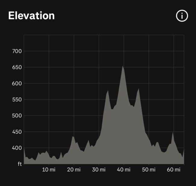
Total miles: 64
Total elevation gain: 889 ft.
The forecast was low 80s with a strong south wind. Our VRBO in Harrisburg was a short downhill ride to the trail. The official Tunnel Hill trail runs from Harrisburg in the north to Karnak in the south.
The plan was to ride from the house to Eldorado, then ride south, meet Mitch in Harrisburg, ride south to Tunnel Hill, then back to Harrisburg. Riding north to Eldorado, the trail went from concrete to cinder to almost singletrack. I found out later that Harrisburg County “maintains” this section of the trail. The strong tailwind and flat terrain made for some easy speed on my Salsa Cutthroat with 45 mm tires (35 mm tires will do you just fine).
The seven-mile stretch north isn’t very scenic. The path takes you past the Harrisburg Fire Department training area and farmland. Part of the trail paralleled US-45, and I came across several homeless people; one man was very friendly, smiling and waving as he sat with all his belongings. On the outskirts of Eldorado, I came across a large, angry-looking woman carrying a baseball bat, so I erred on the side of caution and turned around.
Now heading south, I was greeted by a strong headwind, with few trees to offer relief. Back in Harrisburg and 15 miles completed, I met up with Mitch. We rode in and out of the forest, enduring a headwind and a slight uphill grade. Since the trail is built on an old railroad bed, the grade is 1-3% for long stretches.
The first town south of Harrisburg is Ledford, which had the first mine to ship coal by rail in 1873. In the late 1880s, Ledford was a booming community of 1,200, but in 1930 the mine closed, and the town’s population dwindled. There wasn’t much to see in Ledford, so we continued south to Carrier Mills.
The trailhead in Carrier Mills has a restroom and a picnic table. If you need food, a couple of gas stations are just off the path, including a Casey’s for pizza. Near Carrier Mills, we came across two local couples out for a ride on their e-bikes. I’d say a large percentage of cyclists we saw had e-assist bikes, and it was great to see them enjoying the trail.
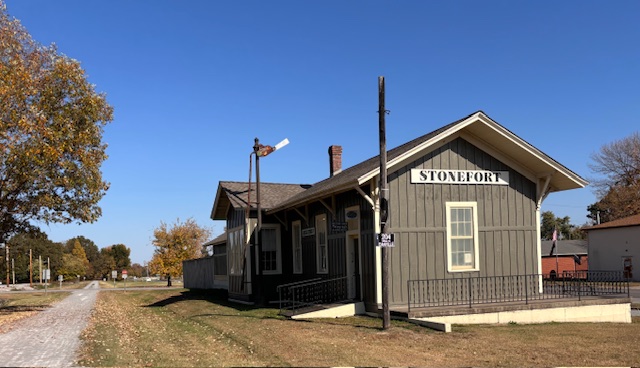
The next town along the trail was Stonefort, settled in 1858 near an ancient (A.D. 500) structure that may have served as a defensive enclosure. A restored depot along the trail houses a museum. It didn’t look open when we passed, so I can’t say what’s inside.
Continuing south toward New Burnside, we came across the two couples we had seen in Carrier Mills, taking a break on one of the many trestles along the trail. We stopped to chat with them while enjoying the beautiful view of the creek below. As locals, the couples shared insights into the trail’s highlights. They said the prettiest stretch was from New Burnside to Vienna. I would agree, but I’d extend it from Carrier Mills to Vienna.
New Burnside was named for Civil War General Ambrose Burnside, who encouraged the construction of the Cairo-Vincennes Railroad to transport coal from southern Illinois mines. By 1878, New Burnside was home to more than 1,200 people. Over the years, as the mine and the railroad declined, the population decreased.
Fun fact: The town of New Burnside isn’t the only thing named after Ambrose Burnside. The way the general wore his whiskers gave us the word burnsides, or sideburns.
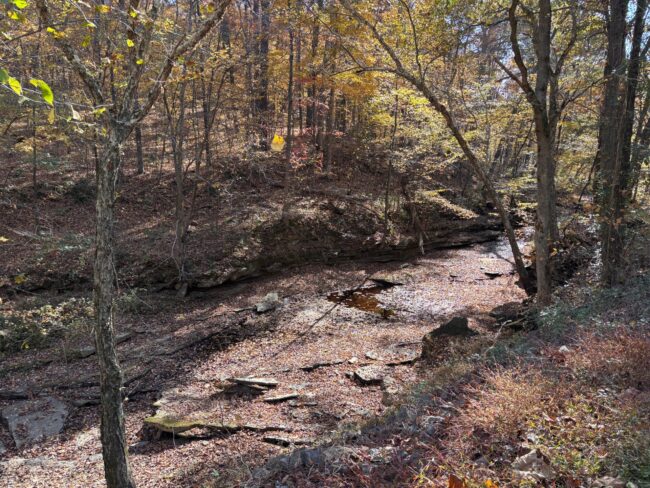
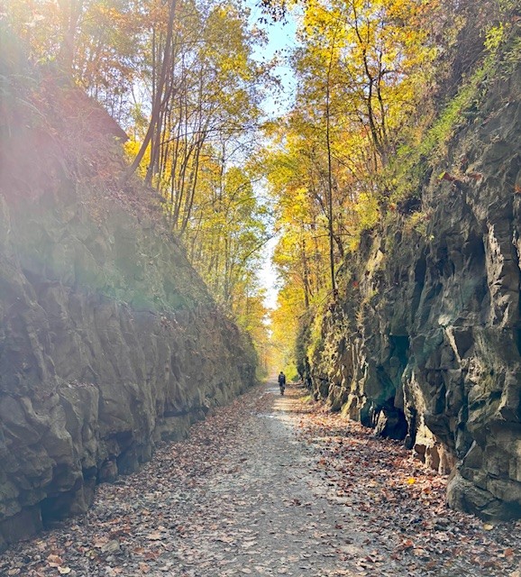
The trailhead at New Burnside has restrooms, several picnic tables, and a water fountain, but not much else. I left Mitch at the picnic table and continued south to Tunnel Hill. Leaving New Burnside, I had a welcome downhill, only to face a several-mile climb to Tunnel Hill. The golden fall foliage was spectacular, with rocky cliffs on one side and a gully with a creek on the other. The creek was stagnant due to the lack of rain, but in wetter times, I’m sure it flows faster.
The Tunnel Hill trailhead is 0.2 miles north of the tunnel. There’s plenty of parking and a restroom. As you approach the tunnel, the air turns noticeably cooler, with a nice, cool breeze. Rock walls flank the path leading to the tunnel opening, and you can see daylight from one end to the other. The tunnel was originally 800 feet long, but a section collapsed in 1929, leaving the 543 feet that remain today.
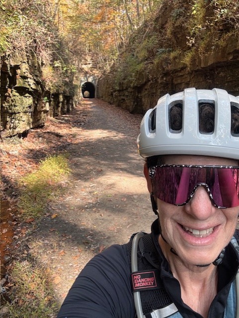
It was a bright, sunny day, and you could easily ride through the tunnel without a light, but for safety, I’d recommend using one because muddy puddles line the sides.
Once on the other side of the tunnel, I turned around and enjoyed the tailwind and a mostly downhill ride back to Harrisburg, completing my 65-mile day.
Day 2 – Vienna to Tunnel Hill to Karnak
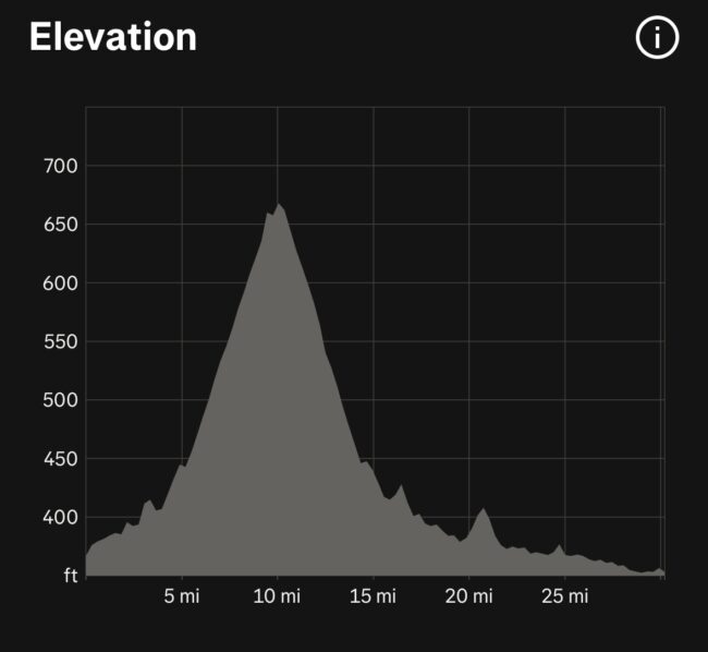
Total miles: 30
Total elevation gain: 436 ft.
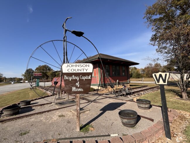
Today we drove 40 minutes from Harrisburg to Vienna City Park. This huge park features a giant penny-farthing, picnic areas, a playground, restrooms, and the Forman Depot Museum, the county’s last surviving depot. Built in 1900, the depot is now the Vienna Visitor Information Center, which includes a museum and will soon include an ice cream shop. Debbie, the volunteer at the center, was friendly and very knowledgeable about the area’s history and what to see in Vienna.
Debbie alerted us to the area’s annual trail race. The Tunnel Hill 100 is a premier, ultra-fast trail-running event held this year on November 14, 2026. Thank goodness we didn’t plan to ride two weeks later, or we’d be sharing the trail with over 1,000 runners!!! If you plan to ride this trail in the fall, double-check next year’s race dates.
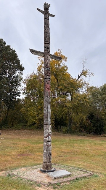
A totem pole in the city park marks the halfway point for the Trail of Tears. President Andrew Jackson signed the Removal Act in 1830. The U.S. government relocated the Cherokee, Chickasaw, Creek, and Seminole tribes to Oklahoma. Tens of thousands of Indians were forced to march along the Trail of Tears that passed through Vienna. It was a terrible time in our country’s history, and it was emotional to stand before this memorial.
Heading north from Vienna to Tunnel Hill, we climbed a subtle 1-3% grade up to the tunnel. But the surrounding beauty was a welcome distraction. Since Mitch hadn’t been with me the day before, we rode through the tunnel and took a short break on the other side at the Tunnel Hill trailhead.
On the descent to Vienna, a cottonmouth snake was warming itself in the middle of the trail. Knowing the area is home to many poisonous snakes, including cottonmouth, copperhead, water moccasins, and timber rattlesnakes, I wasn’t going to stop for a picture!
Back in Vienna, I continued south to Karnak, where Mitch planned to meet me with the car. I planned to ride all the way to the Henry N. Barkhausen Cache River Wetlands Center, but Debbie at the depot said it was closed due to a medical emergency. Unfortunately, I missed seeing the 1,000-year-old cypress trees.
From Vienna to Karnak, the trail wasn’t anything special, with a few rugged sections of deep gravel and cinder. The trail passes through wetland forest, first the Cave Creek Glade Nature Preserve and then Heron Pond–Little Black Slough.
This end of the trail is fairly desolate, and I only passed two riders in 8 miles. Then, close to Karnak, it got a little seedy, and I had two encounters with meth heads. One was riding a BMX-type bike and tried to get me to stop. He wasn’t in distress, so I just kept going as fast as possible. My second encounter was by the campsites. If I hadn’t been alone, I probably wouldn’t have been as frightened or worried about getting robbed. Needless to say, I was happy to see Mitch waiting for me in the parking lot.
Day 3: Hiking Shawnee National Forest
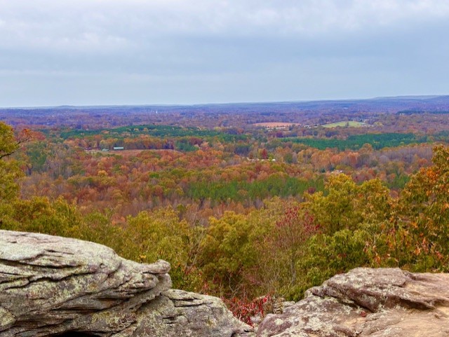
With the trail completed, we decided to hike a few Shawnee National Forest trails. The first one was Garden of the Gods Observation Trail. I can highly recommend this quarter-mile loop. It’s not strenuous, but you can climb many of the rock formations and enjoy breathtaking vistas.
The rock formations result from millions of years of natural weathering. About 320 million years ago, a shallow sea covered this area. Rivers deposited layers of sand and mud along the seashore as the region slowly sank. As these materials accumulated, heat and pressure turned the sand and mud into stone. Eventually, the land rose, and the sea retreated southward, leaving the stone exposed.
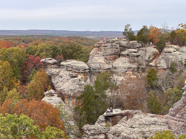
The second hike was just down the road from Garden of the Gods, called Indian Point Overlook Trail. And the third was a bit of a drive, and the last few miles are on a gravel road: Burden Falls. Unfortunately, due to the lack of rain in the area, the waterfall wasn’t running. During heavy rainfall, the area can become flooded.
You can easily spend weeks hiking in the area, including the River to River Trail. The 160-mile trail runs from Grand Tower on the Mississippi River to Elizabethtown on the Ohio River. It typically takes 2-3 weeks to thru-hike the trail, but you can do shorter sections.
It was Halloween, so on the way back to our VRBO house, we stopped to pick up candy in case kids came trick-or-treating. Homes are spread out in that area, so parents drive their kids through the neighborhood. Sitting on the porch, we handed out candy and quickly ran out. It was a great way to end the trip.
Bottom Line
I highly recommend riding and hiking in and around the Shawnee National Forest. Because of the heat and humidity, I’d suggest avoiding the summer months. October was perfect, and the peak fall foliage really enhanced the visual experience.
Resources:
Tunnel Hill State Trail Facebook Group
Sheri Rosenbaum regularly contributes articles and reviews products for RBR. She’s an avid recreational roadie who lives in the Chicago area and a major advocate for women’s cycling, serving on the board of directors and volunteering with the Dare2tri Paratriathlon Club. Click to read Sheri’s full bio or visit her web site sunflowersandpedals.com.
Next Article: Is it really so bad to take the whole winter off the bike?
