 By John Marsh
When my buddy Scott and I started talking last November about doing another “big ride” in 2018, he suggested coming from Southern California to Atlanta (my home) and spending a week or so doing something in this part of the country.
We’ve gotten into a groove over the past few years of doing a tour of some sort every other summer. Two summers ago we rode the Tour de Wyoming together with another buddy. The three of us actually met a few years back on the California Coast Classic, an idyllic ride down Highway 1 (in large part) from San Francisco to L.A.
Two iconic regional bikeways immediately came to my mind: the Natchez Trace, and the Blue Ridge Parkway.
Both have been on my riding bucket list for years, but the Parkway won out for a couple of reasons.
First, two other friends had done separate trips on the BRP in 2017, and I was able to get first-hand intel and ideas from both. One friend did an end-to-end trip, riding the entire 469-mile length of the Parkway with his local riding group, supported by his son driving a van and hauling gear ahead to each night’s campsite. The other did a sort of hub-and-spoke trip with some friends, using popular Strava routes off the Parkway to comprise their ride.
Second, Scott and I both share a passion for beer that is the equal of our passion for riding. Asheville, N.C., near the southern terminus of the Blue Ridge Parkway, is known as “beer city” and has the most breweries per capita of any city in the U.S. I know Asheville well; it’s a bit more than a 3-hour drive from Atlanta and is a favorite getaway spot for my wife and me. So it made perfect sense to make Asheville our “hub” for this trip.
Tailoring a Trip for Two
My first instinct was to try to bring another few of my local buddies along for the ride and map out an end-to-end tour – but our late-June time-frame simply didn’t work for anyone else. Not to mention that I had only about two months’ of riding in my legs at that point after recovering from surgery earlier in the year.
So, knowing it would be just the two of us, with nobody to drive a SAG or otherwise help support us, and that an end-to-end slog was not realistically possible anyway, I had to plan a trip that would be different from both the trips my buddies had done the prior year. Scott and I agreed that keeping every day fun and enjoyable trumped any sort of daily mileage grind or overall distance goals.
The Parkway is, after all, a nearly 500-mile roller coaster of a road – you are nearly always either climbing or descending. So you’re practically guaranteed to get a good, hard, challenging ride no matter the distance you choose to bite off on any given day. The Parkway features a lot of grades at 6 to 8 percent, but with some long stretches that reach up to 10 – so you’d best be prepared both physically and with appropriate gearing.
The 7-day trip I devised worked great for the two of us (and would work just as well for a group of any size, really). It should also work for any section of the Parkway; in fact, we’re already thinking of a similar trip from the northern terminus in Virginia (perhaps including Skyline Drive, which adjoins the Parkway on the northern end), or maybe somewhere nearer the middle of the BRP.
Here’s what we did:
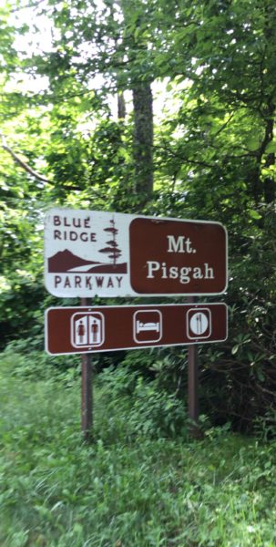
I researched other Parkway tours online and found a couple of great inns located right on the Parkway, one south of Asheville and one north. We stayed two days and two nights at the Pisgah Inn south of Asheville (near Mt. Pisgah), three days and nights in Asheville, and another two days and nights at the Switzerland Inn, in Little Switzerland, north of Asheville, also directly on the Parkway.
From the two inns, we did an out-and-back ride each day, one day heading north, one day heading south, to pre-determined destinations on the Parkway. We had a couple days with 5,000 feet of climbing packed into less than 50 miles. Our Queen Stage included climbing Mt. Mitchell, the highest point east of the Mississippi, at 6,684 feet – and included 7,000 feet of climbing in just 52 miles.
While in Asheville, we did a big day that combined a long climb up to the Parkway, and then another stretch on the Parkway itself before returning to Asheville. The other two (weekend) days, we stayed off the Parkway and kept it local, doing versions of a ride we learned about from an Asheville cyclist.
In avoiding the Parkway on the weekend, we followed the advice of numerous riding friends, and my own experience from driving on the Parkway – namely, that weekends are traffic-choked and much less safe for cycling, especially near a bigger city like Asheville. The BRP is a 2-lane ribbon of road with endless blind curves and quite a few tunnels. (More on both of those, and safety in general, later.)
We supplemented our seven days of riding with visits to around 10 (forgive us for losing track!) breweries during our long Asheville weekend.
After providing specifics on each day’s ride – and some intel on Asheville’s beer culture – I’ll finish up with a list of tips for riding on the Blue Ridge Parkway.
Trip & Ride Details
Day 1 (Wednesday):
Because the drive from Atlanta to the Pisgah Inn was about 3.5 hours, we decided to hit the road mid-morning and ride in the afternoon after arrival and check-in.
We couldn’t have had a better omen about how our trip would turn out than the fortuitous lunch spot we found in Waynesville, N.C., about 45 minutes from the Pisgah Inn.
As we drove past it, we both noticed a sign that read Mad Anthony’s Tap Room. It was an utterly nondescript building – but I immediately hit the brakes, did a U-turn and put in at Mad Anthony’s. Excellent choice! With 50 craft beers on tap, and great food to boot, we couldn’t have asked for a better first meal on our tour!
The (Planned) Ride: Pisgah Inn north to the North Carolina Arboretum – out and back, 30 miles, 3,300 feet climbing.
After checking in at the Pisgah Inn, we kitted up and got on the bikes mid-afternoon. Because we didn’t have time for a longer ride anyway, I had planned a fairly short, spin-the-legs-a-bit ride just to get a feel for riding on the Parkway. The ride turned out even shorter than planned.
I was unaware that there was road construction happening on the section of the Parkway between Mt. Pisgah and Asheville, so we only managed 18 miles that day. We still got in 1,900 feet of climbing in those 18 miles to remind our legs what was to come. Thankfully, and after checking when we returned from the ride, that was the only section along our route that was affected.
Tip: If you’re considering a Parkway trip, check the National Park Service site, https://www.nps.gov/blri/index.htm, and the official Parkway site, https://www.blueridgeparkway.org/, for road construction and closures. Both sites offer plenty of other useful information, as well. There’s also a Parkway mobile app available on both iTunes and Google Play.
Day 2 (Thursday) – The Ride:
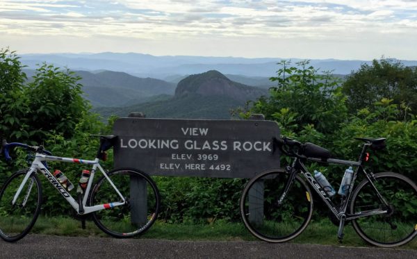
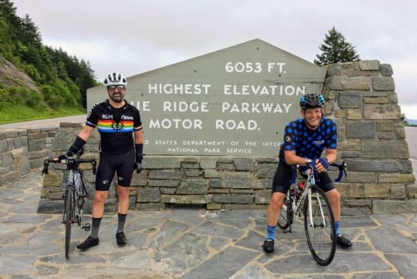
Pisgah Inn to Richland Balsam Overlook (the highest point on the Parkway, at 6,053 feet) – out and back. Totals for the Day: 46.4 miles, 5,016 feet climbing.
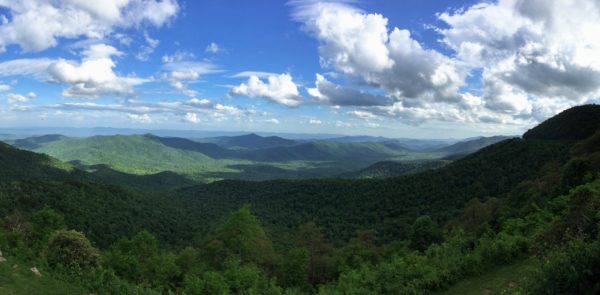
We headed out right after breakfast, and the temps ranged from the mid-50s to low-60s all day, with an overcast sky. This was one of my favorite rides of the trip. Unlike some other sections of the Parkway, much of this stretch runs along a ridge of the Blue Ridge Mountains, affording seemingly endless, gorgeous vistas on both sides of the road.
It also featured about 15 miles of sustained climbing toward our destination at Balsam Overlook. The climb was long and hard, but reaching the iconic sign perched just off the road at the Overlook provided the day’s first reward. We were pumped up a bit more by a couple of motorcyclists we saw at the top who noted their respect that our “engines” were our bodies.
That long climb up also meant that we got to enjoy an equal descent along a sustained grade of about 8 percent on the return. That’s one of the great things about the Parkway’s roller coaster makeup – much of the grade on descents requires little, if any braking around the numerous curves, which makes for thrilling yet comfortable descending at speed (if you like that sort of thing; Scott and I sure do!).
Tip: There are segments on the Parkway – and this is one of them – with no access to water for long distances. We were told by someone at the Inn that there was water at a rest stop about 15 miles into our ride, so we planned for that. That person was wrong, it turned out. So as we rode on and pondered what to do, we decided we would just ask someone at the Balsam Overlook once we got there for any extra water they might have. Turns out, we didn’t need to do that, after all.
As we pedaled past a turnout, in a super quiet section of roadway, while talking about our water situation we were overheard by a man standing outside his pickup truck parked in the turnout. The guy was probably 100 yards away but somehow heard us say the word “water” and yelled at us that he had some water! We turned around, graciously accepted his water, and discovered that he and his dad were running their dogs off the Parkway, in coordination with others doing the same – chasing bears to keep the area a bit safer. Bear story No. 1.
Quick note about the Pisgah Inn:
Near Mt. Pisgah, the Inn looks much like an old-school 2-story motel with two separate wings, along with a lodge-like restaurant area, observation deck and gift shop. The rooms are updated nicely and all offer stunning views across the valley and the mountains beyond. The food is quite good, as well. And, again, it is right on the Parkway. You roll out of your room and are on the road in 10 seconds.
Day 3 (Friday) – Pack up and drive to Asheville.
Because we arrived well before check-in time, we opted to kit up before the hour-and-15-minute drive and ride from the car.
The Ride: Parking .5 mile away at the corner of Merimon Ave. and Beaverdam Rd., ride up Elk Mt. Scenic Hwy. to the BRP (approx. 7 miles, 1,700 feet climbing). Continue on the BRP to Craggy Gardens (approx.11.75 miles, 2,800 feet climbing). Craggy Gardens back down the BRP to Elk Mt. Scenic Hwy., then down Elk Mt. to the parking lot (approx. 18.75 miles, 528 feet climbing). Totals for the Day: 37.5 miles, 4,652 feet climbing.
This is a terrific, climbing-packed way to experience one of the best-known rides in Asheville, along with a lovely, meandering ascent on the Parkway to Craggy Gardens, the first visitor center north of Asheville.
I had ridden up Elk Mt. Scenic Hwy. once before, and have driven up it numerous times (my wife and I often stay at the Sourwood Inn, which sits at the top of Elk Mt.).
Elk Mt. is a testy, 7-mile climb loaded with switchbacks and a lot of grade that tilts up to 11 or 12 percent near those bends – with a butt-kicking stretch up to the summit that exceeds 20 percent. Just shy of the summit, on the right side of the road, is an overlook back through a valley into Asheville. Take a break, climb down onto one of the massive painted boulders there, and enjoy your hard-earned view.
From the summit of Elk Mt., it’s about two more miles to the Parkway. On this stretch, Scott and I rounded a bend and both started trying to figure out what the form was in the road about 200 yards distant. As we rolled closer we watched with amazed joy (and slight trepidation!) as the juvenile black bear scampered into the woods. Bear story No. 2.
The 12 miles up to Craggy Gardens is on a long, side-hill stretch of the Parkway largely canopied, with intermittent views on the open side of the road. The canopy is much appreciated on days like this one, where the difference in temperature when out in the open under the sun is immediately noticeable.
This stretch also featured one of the longer tunnels on our trip, which was no picnic either way. Ascending meant a long stretch in the tunnel, slogging up the 8 percent grade. Descending brought added angst negotiating the combination of speed, curve and auto traffic.
Day 4 (Saturday) – Bakery Ride.
Totals for the Day: 38.7 miles, 2,730 feet climbing.
After getting checked into our downtown Asheville accommodations following the Elk Mt. – Craggy Gardens ride on Day 3, we walked to Wicked Weed Brewing for lunch – where fate smiled on us yet again.
Scott noticed the shaved legs of our waiter and instantly pegged him for a cyclist. Scott was exactly right – he was a local Cat 2 road racer – and we immediately asked our new friend for ride recommendations for the weekend.
The first one he suggested was the ride we had just returned from. His second suggestion was the Bakery Ride, a local Saturday ride along the French Broad River and into the hills northwest of downtown Asheville. We were able to find a route map online, and we did the Bakery Ride route as our Day 4 ride.
It was much more akin to a typical “countryside” ride I’m used to outside of Atlanta, with notes of exurbia and civilization interspersed with long stretches that feel like you’re away from it all. The ride had the added benefit of long, lovely views into the surrounding hills and mountains, along with a good amount of climbing (but not nearly as much as a similar day on the Parkway).
We liked the route so much that we decided to go back the next day and do a small portion of it as our “rest day” before our Queen Stage on Monday.
Day 5 (Sunday) – Partial Bakery Ride.
Totals for the Day: 10.7 miles, 955 feet climbing.
We started feeling like we were riding a lucky streak when the skies opened up – right as we finished the ride and started putting the bikes on the car. The exact same thing happened the next day after our big ride. Not five minutes from finishing did a massive thunderstorm roll through. We never did get rained on while on the bikes during our weeklong tour.
The day’s short course gave us ample time to drive down to the fantastic Sierra Nevada Brewing Co. by the Asheville Airport in Mills River.
Day 6 (Monday) – Pack up and drive about 1:15 to Little Switzerland.
The Ride: Switzerland Inn south to Mount Mitchell State Park, climb Mt. Mitchell (highest point east of the Mississippi River, at 6,684 feet), out-and-back.
Totals for the Day: 52.5 miles, 7,005 feet climbing (5,000 feet in the first 26 miles).
This was our favorite ride – one of those uber-tough days you live for in road cycling that tests you to your limits and delivers the greatest satisfaction because of that.
Mt. Mitchell is not to be missed if you’re riding on this section of the Parkway. It’s an iconic climb in the East, and just getting there is half the “fun.”
From our starting point at the Switzerland Inn to the summit of Mt. Mitchell was 26.2 miles and 4,994 feet of climbing. (That would equate to a 19,000-foot century, for those of you scoring at home!) The climb up Mt. Mitchell itself is about 4.75 miles and 1,404 feet. That’s an average grade of about 5.6 percent, but there are testy stretches of up to 12 percent on the climb.
It’s certainly not the toughest climb out there, but seldom do you have the chance to summit the highest point on one side of the continental U.S., which makes it pretty darn cool.
Another 2,000 feet of climbing on the return leg brought us to just over 7,000 feet on the 52-mile day. We certainly earned our beers that evening as we sat in rocking chairs in front of the massive fire pit at the Switzerland Inn that overlooks yet another gorgeous run of mountains into the distance.
Day 7 (Tuesday) – The Ride: Switzerland Inn north, out-and-back.
Totals for the Day: 21.8 miles, 2,451 feet climbing.
We decided to make this a play-it-by-ear ride, in equal parts because we just didn’t feel like doing two monster days in a row, and we wanted to watch an early World Cup game back at the ranch. So we pedaled out as far as we felt like, then turned back for home. (Kudos to the accommodating staff at the Switzerland Inn who set us up mid-day in the closed bar to watch our game!)
(Our original ride plan was Switzerland Inn to Rough Ridge Lookout (65 miles, 6,900 feet climbing).
This little stretch of the Parkway that we did, north of Little Switzerland, was the least scenic of our seven days of riding. It’s a largely enclosed section of the BRP that mostly feels like riding through the forest rather than in the mountains (though you certainly don’t escape the climbing!). Still beautiful; just different. I’m sure if we had done our original route, we would have climbed back into yet more gorgeous views.
Quick note about the Switzerland Inn:
More of an old school lodge feel than the Pisgah Inn, this sprawling complex features the main lodge building with an adjoining restaurant and bar, a row of small shops adjacent, as well as individual A-frame “chalet” cottages on the property. The entire complex is on a ridge with a stunning view over the mountains and has numerous games and activities at hand (horseshoes, a swimming pool, corn hole), and a super nice fire pit area lit every evening. Just like the Pisgah Inn, you can roll from your door to the Parkway in seconds.
Asheville’s Beer Scene
If you’re a beer lover, walking around downtown Asheville is a kid-in-a-candy-store type experience. In some spots, you can barely walk a block without passing a handful of breweries. Especially if you have an adventurous streak in your taste for beer, you’re bound to find something to enjoy.
The breweries range in size from those that brew in large quantities and distribute regionally to those that operate 2-barrel systems and sell most or all of their product on-site, from opulent beer palaces (the $1 billion Sierra Nevada facility and 100-acre grounds) to speak-easy cellar bars (One World’s “hidden” downtown location). Of note for hungry cyclists is that not all the breweries serve food, so if you need a meal with your beer, choose accordingly.
In Asheville, you can pick up an Asheville Ale Trail “Field Guide,” a detailed pamphlet listing all the local and regional breweries, along with maps, etc. You can also check out AshevilleAleTrail.com and get the free app on Google Play and iTunes.
During our three days in Asheville, Scott and I managed to visit the following:
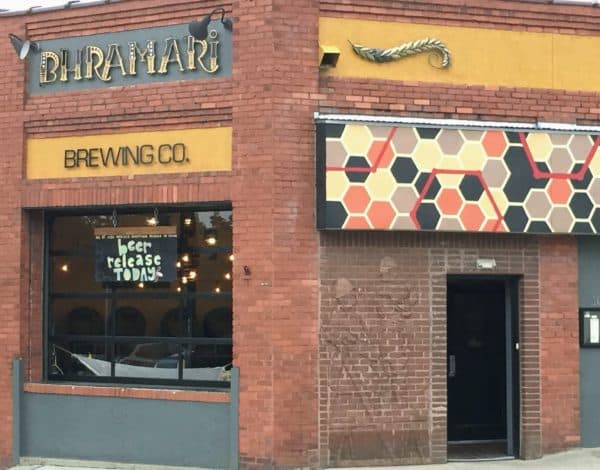
- Bhramari Brewing Company
- Catawba Brewing Company
- Green Man Brewery
- Hi-Wire Brewing Company
- One World Brewing
- Sierra Nevada Brewing Company
- Thirsty Monk Pub & Brewery
- Twin Leaf Brewery
- Wicked Weed Brewing
Safety Tips on the BRP
Front and rear flashers are a necessity.
You need to be seen on the Parkway from both sides. There are innumerable long, blind curves, and dark mountain tunnels every few miles. Make sure you have dependable, bright flashers both front and rear running at all times on the Parkway.
You might also choose to use a nighttime “to see” front light in the tunnels (though it might be difficult in some instances to turn on that light when descending into a tunnel at speed).
Tunnels can be discombobulating and a bit scary.
There will be drivers on the Parkway who just cannot spare the extra few seconds to safely drive behind you through a tunnel. Instead, they will zoom around you in the dark, confined space of the enclosed 2-lane road. Just expect it. (The worst are the ear-splitting Harleys that zoom past in a tunnel.)
You should also expect, especially in long tunnels, to get somewhat disoriented. It’s not that you get “tunnel vision,” but rather the absence of light almost gives you the feeling of riding in a vacuum, with a limited focal point to engage your eyes in helping keep your balance. I found that in such cases just holding your line, focusing on your pedal stroke and, when in view, on the proverbial “light at the end of the tunnel” helped me.
Be prepared to direct traffic around you.
In most places, the speed limit on the Parkway is 45 mph, so seldom will a car come upon you unnoticed. Especially while climbing, most reasonable drivers will hold back and not try to overtake you in the middle of one of those blind curves. (Though some will; again, expect it.) At your earliest opportunity, wave them past you when you see that the coast is clear. You can also be nice and put up a “stop sign” to the car behind you if you see a car approaching in the opposite direction.
In short, directing traffic will make your ride safer, so be prepared to do it.
Ride single file and maintain appropriate spacing between riders. It’s already tight enough on the 2-lane Parkway. Riding two abreast (which we witnessed a couple of times) – while it is within your legal rights – is just not a good idea, for the reasons already mentioned. Instead, keep it single file and you’ll be safer for it.
It is also advisable to keep in mind the spacing between riders. If it’s just two of you, either try to stay close to each other’s wheel, or stay far enough apart that a car can pass the rear rider with enough room to tuck back in behind the front rider before passing him or her, too. The same dynamic goes for bigger groups.
In some areas, there is no water (or food) available.
The big visitor centers on the Parkway will have water and restrooms (and often snacks, as well). But, as we found out the hard way, smaller facilities at trailheads, for example, might only have waterless toilets and no running water. So plan ahead and bring an extra bottle if in doubt, and carry enough food to keep you bonk-free.
Gear up for lots of climbing.
I have ridden an 11-28 in the mountains for many years, but the older I get, the more occasions I’ve had where I felt I could benefit from easier gearing.
Knowing I only had two months’ saddle time after recovering from a surgery earlier in the year to prepare for the ride, I upgraded my bike to a medium-cage (Shimano’s term for long-cage) rear derailleur and installed an 11-34 cassette. It’s something I had contemplated for years, and this was exactly the kick in the butt I needed to actually do it.
It was a great decision! I used the 30-tooth gear extensively on the trip. It was just the right amount of additional gearing to enable me to climb without getting anywhere near the red zone. And knowing I had another, even easier, “bailout” gear was nice, too. I only tapped that 34 one time – on that 20+ percent stretch at the top of Elk Mt.
Slow and steady wins the race.
The gearing allowed me to ride at more of a “tour pace” than I often do in the mountains. Even on some previous tours with extensive climbing – and, certainly, in mountain centuries I’ve done – I have pushed myself right to the brink of my “magic number,” the heart rate beyond which I go anaerobic and really start to struggle.
On this tour, I kept my HR 20 or more beats per minute below that level, and just went nice and easy nearly always. Which made it that much more enjoyable overall.
Enjoy the views.
The Parkway winds through some of the most spectacular scenery on offer in the Blue Ridge and Appalachian Mountains. Soak up the views while you ride (while keeping focus on the road and surroundings, of course), and take advantage of the many turnouts and overlooks along the route. Stop, rest, take photos, breathe deeply and take it all in.
The Blue Ridge Parkway is one of the most beautiful bikeways in the U.S. and a road cyclist’s dream come to life. I’m thrilled I got the chance to ride it, and I can’t wait to get back again.
I would recommend disc brakes. When people ask me about the climbing I always say that isn’t what scares me, it is descending and not knowing if I can slow enough for the next curve.
In addition to flashing lights you should have a front light that is capable of providing some illumination in the tunnels. I also wear glasses that allow you to flip up the dark lenses as you enter the tunnel. Otherwise your eyes may not adjust quickly enough to see.
Pavement in the tunnels seems to be pretty good now, but be careful you don’t go flying through and hit a pothole in the dark.
If you are planning and end-to-end tour do not set a fixed number of miles each day, but base your ride on the amount of climbing. We (older riders) found that an 8 day ride with about 6,000 feet of climbing per day worked well. Some days were 40 miles, some 80. My three trips have all been north to south.
Walt, I agree with you about running a “to see” headlight. Next time I tour on the Parkway, I will ride with both a front flasher and headlight to illuminate the tunnels.
You’re right that the pavement on the Parkway was by and large in great shape. We saw very little that was less than good.
I do think rim brakes are fine on the Parkway, though. On the sections we did, there were few descents that required much braking. Usually, scrubbing just a bit of speed was all that was needed to handle most curves. (Of course, I know that descending speed — and comfort level — is a hugely personal matter. So whatever makes you most comfortable, go with that!)
Enjoyed your article and comments. I solo credit card biked Skyline Drive and the Parkway three years ago. The article captures the feel of the ride. The weather can change abruptly and be different up high, so it helped to carry an extra layer and rain pants. The views are spectacular on a clear day!
I need to add this trip to my list.
Hmm, I paused at the comment on Day 2 that the long 8 percent grade was great for descending with little braking. I’m 200 lbs, and on an 5 percent grade I hit 45+ mph. I’m impressed that that requires little braking.
Thanks so much for posting this! I was planning to do the ride solo from Front Royal to Asheville, but after reading your post, I don’t see a problem with saving time and $$ doing day rides and driving. The traffic on the weekends would be unavoidable and I’ll stick to drinking beer on those days! I also prefer to stay low budget and camp on these trips. The thought of doing those hills on a loaded bike is unappealing, even after I completed the GDMBR last summer!