
By Stan Purdum
Nearly 20 years ago, I pulled out on the fourth day of what I’d planned to be a longer bicycle tour because heavy rain had set in and was forecast to continue for a couple days more. It was the right decision, but it left me disappointed — partly because the leg of the journey that promised some of the best riding lay just beyond where I ended the ride.
My plan had been to follow the upstream route of the mighty Ohio River where it borders the state of Ohio —from Cincinnati to East Liverpool — switching from shore to shore, depending on which one offered the best bike road in each area. By the evening of the third day, I was in Gallipolis, on the Ohio side, having made good progress.
I spent that night in a Gallipolis motel. When I awoke, rain was falling. I pressed on nonetheless, and made it as far as Pomeroy, Ohio, but by then rain was falling harder, and I learned that the forecast for the next two days was no better. I phoned my wife who drove to Pomeroy and rescued me.
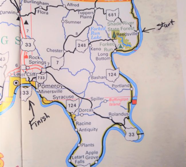
But as I said, the pullout left me disappointed. While I had not gotten to view the road ahead, I could see from area maps that the local route I would have used after Pomeroy — Ohio Rt. 124 — was a low-traffic two-lane road that followed almost every bend of the river as it snaked around a peninsula that on the map, resembled a short and wide version of Italy’s “boot.” Rt. 124, part of the Ohio River Scenic Byway, passed through a few small villages, but being away from the main thoroughfare through the region, it looked better for cycling than any of the roads I’d already ridden on the trip.
In the years that followed, I rode lots of interesting and challenging places, but circumstances never worked out to return to that particular part of Ohio. Nonetheless, I occasionally thought of the 124 route, imagining what great and scenic riding it would have been. In fact, that unseen route began to take on mythic proportions in my mind.
Recently, however, we moved to Gallipolis. The move had nothing to do with cycling, but since Pomeroy is now only about 40 minutes away by car, I eventually decided to drive to that area and cycle Rt. 124.
Logistically, it now made sense to pedal 124 from north to south, so I started in the tiny village of Reedsville, which is also the location of the Belleville Locks and Dam (view is from the Ohio side). Free parking and public restrooms there make it a good start or end point for this ride.
The Belleville locks and dam combo is one of 21 such installations on full length of the Ohio River —between its origin at the confluence of the Allegheny and Monongahela Rivers at Pittsburgh, Pennsylvania, and its end where the Ohio empties into the Mississippi River at Cairo, Illinois. Nine of those dams are on the river where it borders the state of Ohio.
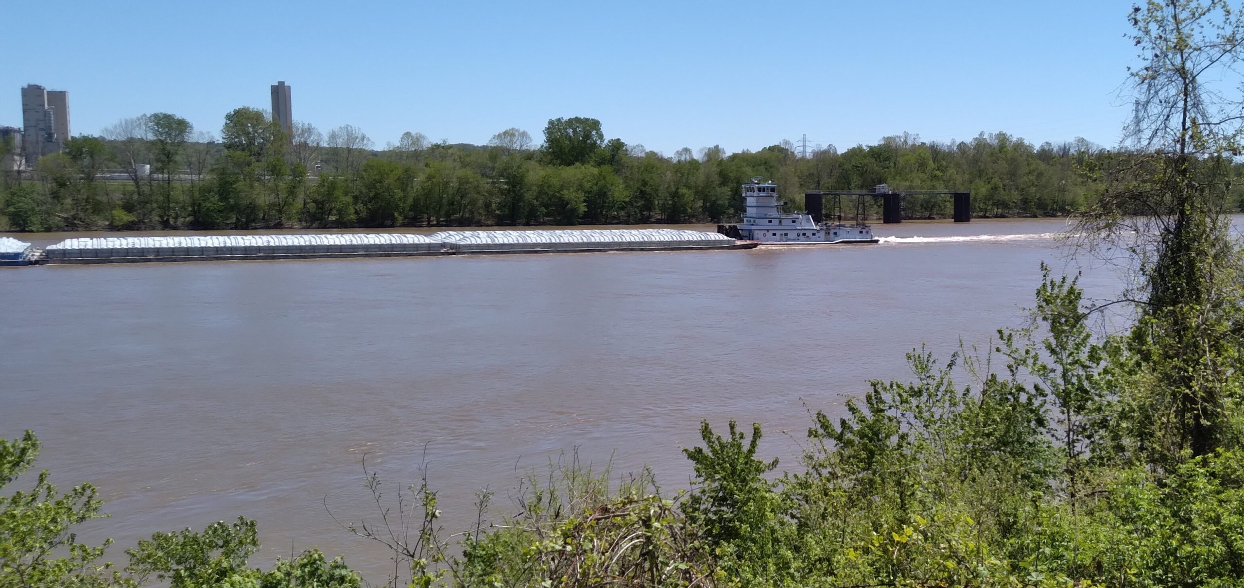
These dams have changed the river from its naturally shallow state to one sufficiently deepened to support commercial traffic including the towboats that propel gangs of barges up and down the Ohio (they are actually push-boats, but the towboats name is a holdover from the declining years of the steamboat era, when steamboats began to tow wooden barges alongside to earn additional revenue).
The effect of the raised water level has caused the Ohio to broaden and makes it appear more as a series of reservoirs than a flowing watercourse, though the flow is still visually obvious when you see fallen limbs floating in the stream.
Most of the way, Rt. 124 has no paved shoulders, but the traffic is so light (an average of maybe one vehicle every five minutes) that riding left of the white line is no problem, and the pavement is in excellent condition. Three times, groups of motorcyclists passed me as well. A biker I met at a pull off told me that Rt. 124 is a favorite among motorcyclists.
Heading south from Reedsville, the river was always on my left, and often nearby and visible. In some places the road ran a quarter mile or so away from the river, and in other places the view of the water was blocked by trees bearing the high green foliage of late spring. But opportunities to see it from the bike occurred repeatedly throughout the journey.
The land along 124 is rural, with occasional houses on my right with porches facing the river. The quality of the housing varies from fabulous to shabby, but even the low-end houses have a million-dollar view.
Not far below Reedsville, I passed a sand quarry on the non-river side of the road with an overhead covered conveyor belt leading from the pit across the road and on toward the river a quarter of a mile away, making the pit operator a customer for the towboats. The company’s materials, including sand and gravel, are carried by the conveyor belt to a load-out point on the river where they are poured into barges. It is not uncommon on this ride to see powerful towboats pushing as many as 15 barges, ganged together in five rows of three barges each.
I next passed the entrance to Forked Run State Park, which offers camping, swimming, fishing, hiking and other outdoor activities, and a couple of miles below that, I came to the next tiny community, Long Bottom.
Hold the jokes; in river jargon, a bottom is low-lying land immediately adjacent to a waterway and subject to overflow during floods. In dryer periods, it was often difficult for residents to envision just how far the river would spread in high-water times. The first settlers in Long Bottom arrived before 1800, but some were apparently shortsighted when plotting their village, for a river overflow in 1894 swept away virtually all their houses and other structures. The town was rebuilt further from the river, and even the road, which was severely damaged, had to be relocated to higher ground.
Rt. 124 makes a quick turn toward the river in Long Bottom, and on that corner sits a Methodist Church, constructed in 1895, after the swollen river had taken the congregation’s previous meeting house. But though the building has continued in service since then, there have been other water-caused problems. During the flood of 1913, water entered the church, damaging windows and plaster. In response, the congregation raised the building and added a basement of concrete block — which filled with over a foot of river water during the most recent flood in 2004.
Another five miles of pedaling brought me to Portland, mostly a cluster of houses. But just south of it on the non-river side of the road is a small park commemorating the Battle of Buffington Island, the only significant Civil War battle on Ohio soil. It was fought on July 19, 1863 between Confederate raiders led by Brigadier General John Hunt Morgan and Union cavalry units under Brigadier Generals Henry Judah and Edward Hobson, aided by two Union gunboats on the river.
The Confederacy had sent Morgan’s raiders into Ohio to try to draw as many Union forces as possible away from fighting in Tennessee, but despite plundering their way across the southern part of Ohio, they had not been very successful in doing so. They were now trying to escape across the river.
Though called the Battle of Buffington Island (the island still exists in the river near Portland), the battle was mostly on the Ohio shore. The Union forces were the victors, but Morgan and some of his men escaped the battle and fled north, hoping to find another crossing point. A few days later, the general and his remaining forces were captured, still in Ohio,.
I stopped at the four-acre park, which tells the story of the battle on signs in a kiosk and includes maps of the action. Though having nothing to do with conflict, the park also includes a large conical mound 20 feet high and 125 feet in diameter at the base, covered with grass. It’s typical of mounds known to have been built by the Adena Culture (circa 800 BC-AD 100), but the cultural affiliation is not known for certain. During my visit, children were playing on the top; their family was picnicking nearby.
The next few miles took me through agricultural land, over a long but not particularly steep hill and then across the top of the “heel,” the only section where 124 moved away from the river, though only briefly. It soon returned as I pedaled around the “toe” of the boot, passing through Apple Grove, Letart Falls, Plants and Antiquity, none of them large enough to be incorporated communities. But Plants was the location of another lock and dam, this one named Racine (view is from the Ohio side), for the nearby community. This dam has a hydroelectric generating plant on the Ohio abutment of the dam.
A short distance further, and I came to the village of Racine, population 664 (in 2019). It’s a pleasant looking place and is large enough to offer a few services — a gas station, Subway shop, Dollar General store, and a family restaurant named Sikorski’s, where I had a delicious plate of hamburger gravy over mashed potatoes with sides of green beans and watermelon for a nice low price.
With only seven miles between Racine and the larger community of Pomeroy, there was more traffic as I continued my ride, but not so much as to make the ride difficult. As I left town, the shoreline on the West Virginia side of the big river was dominated by a coal-burning electric plant with very tall chimneys, as well as an older inactive plant in the process of being demolished. A man I spoke with in Racine told me that every so often, he noticed something else gone from the old plant.
Three miles before Pomeroy, I rode through the village of Syracuse, which looked similar to Racine but I didn’t notice any services there.
Shortly thereafter, I arrived in Pomeroy, which is crammed into a narrow stretch of land between the river and cliffs. It virtually shouts “river town” since the broad expanse of the Ohio is practically in the laps of the businesses arrayed along the main street, all facing the water. Though the community has only about 1750 residents, it bustles, being the seat of Meigs County. See a quick video of Pomeroy here.)
Pomeroy was laid out in the 1830s by an industrialist named Pomeroy to develop the many coal seams that were near the river, as well as get salt from the area brine pools. With coal so readily at hand to fire the salt furnaces, the location was ready-made for development. Neighborhoods grew up the hollers leading to shelf where the business and industry stood, and everything faced the river.
I was back where I’d abandoned my ride 20 years ago. My imagination had it right. This was a mythic ride!
Stan Purdum has ridden several long-distance bike trips, including an across-America ride recounted in his book Roll Around Heaven All Day, and a trek on U.S. 62, from Niagara Falls, New York, to El Paso, Texas, the subject of his book Playing in Traffic. Stan, a freelance writer and editor, lives in Ohio. See more at www.StanPurdum.com.