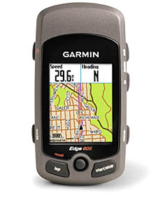
Garmin Edge 605 GPS Cyclecomputer
By Fred Zahradnik

|
HOT!
|
NOT!
|
www.garmin.com |
Garmin expands its cycling-specific GPS line for 2008 with the introduction of the Edge 605 and 705. The 605 reviewed here features a color screen with moving map display, an accurate and high-sensitivity satellite signal receiver, and wireless operation. The 605 is positioned near the top of the Garmin cycling line, with the black-and-white-screen 305 and 205 below it, and the 705 above it.
The 605 is a well-thought-out, well-designed, well-built and feature-rich cycling GPS. If you’re used to running wires around your fork and frame to mount a conventional cycling computer, you’ll welcome this totally wire-free instrument. And there’s no need for wheel calibration because you’re getting data from satellites, not your wheels on the road. This makes it easy to switch the unit among bikes without sacrificing accuracy or recalibrating.
The 605 has some shortcomings compared to the top-end 705 (priced about $100 higher). But the 605 could be the right choice if you don’t need a heart monitor or power meter compatibility.
Garmin gets credit for making a significant investment in cycling-specific GPS products. No other GPS maker is even contending in this category.
Intuitive Operation
When I reviewed the Edge 305 for RBR last year (see that review in the Premium Site’s Product Test archive), I liked its features but noted that its simple, black-and-white map screen was very limited for navigation. Garmin has changed that by packing the 605 and 705 with features you’d expect to find only in good GPS units for motor vehicles.
The 605 has a 1.4×1.7-inch display (2.2 in. or 5.6 cm diagonal). The screen has ample room for the moving map display as well as multiple-mode displays you can customize.
You control the 605 with a mode button, a menu button, lap and start/stop buttons, a rubberized thumb stick and a pair of zoom buttons. That sounds like a lot to learn, but the buttons are quite intuitive in the way they interact with the screen, and I mastered them with just a little practice and the quick-reference guide.
The buttons were easy to locate and use during rides, even when I wore lightweight long-finger gloves. I especially like the way you can flick the thumb stick to automatically activate the backlight and switch among customized displays. The light is adjustable and makes the screen visible in full sunlight when maxed.
Awesome Optional Maps
The 605 comes with simple basemaps but to use it to full advantage there are about two dozen Garmin maps available on micro SD cards for countries and continents. Slide City Navigator North America into the 605 and you’ll see even small back roads across the U.S. and Canada. These maps include “points of interest” such as restaurants, campgrounds, emergency services and more. The North America version, for example, includes six million (that’s right, million) points of interest.
Navigation Features
The addition of GPS to a cyclecomputer gives you a range of powerful features. Here are some examples:
- Set a waypoint (your home or any starting point) and use the GPS map and bearings to find your way back, complete with turn-by-turn directions and street names (with optional city navigator map) and a “distance remaining” readout. If you are riding off-road, the map and directional cues will get you to your destination as well. >
- Save any ride to your history file and re-ride it later by calling it up. The 605 will even calculate a route from your current position, showing you how to get to the start of the stored ride.
- Navigate to an address or point of interest (nearest grocery, for example).
- Save any location as a favorite (trailhead? coffee shop?), select it, and navigate back from anywhere.
For this review, I installed the optional City Navigator North America map ($140). The name is a misnomer because the map also has plenty of detail on rural areas. All of the little back roads I travel in training are accurately portrayed. The map’s accuracy, along with the ability to pan and zoom, make the 605 a truly useful navigation aid.>
Under where to in the menu system you may select history (navigate any stored ride); saved ride (ride route from any source, such as a route downloaded from the internet); back to start (takes you to your starting point); and find places — including favorites, addresses, intersections, food and drink, gas station, lodging, attractions, transportation, shopping, bank & ATM, recreation, community, hospital, auto services, and others.
Example: I asked the 605 for ???food & drink??? near my home. It accurately returned 49 locations, including addresses, phone numbers and the ability to save, map, or go to each of the locations. If you select go to, the map will appear with your route highlighted.
Automatic Training Log
A GPS cycling computer captures lots of data. It tracks your route in detail, your speed at all points along the ride, your average and maximum speeds, and your elevation. You can use the Edge 605 to create a detailed training log without writing a thing. It comes with software that lets you log and chart your workouts, or you can get even better data display and data/route sharing capability from the online MotionBased training log and analysis service.
Customizable Display
Custom data fields can be displayed, and you can have multiple custom settings (bike 1, bike 2) — kind of like pushing the automatic seat and mirror memory buttons in a Lexus. You can have as many as eight separate data fields in the display (yes, they’re all easily readable), including elapsed time, current speed, trip distance, time of day, calories burned, heading, accuracy (in feet) and elevation. Or you can pare it down to two fields, such as elapsed time and current speed, and the numerals will get larger to take up the screen.
I especially like keeping the heading display visible when riding in unfamiliar territory. It tells the compass direction in which you are moving.
Simple Installation
The Edge 605 comes with sturdy and simple nylon mounting brackets for the stem or handlebar. Just select the location, snug down the included zip ties, and you’re ready to clip in the 605 and go. It takes about 30 seconds. Garmin uses sturdy composite nylons for the 605 body and brackets, so they promise to hold up even to hard off-road use. Built-in rubberized backing prevents the mount from slipping, but it helps to use a pair of pliers to pull the zip ties tight.
Summary of Data Fields
These are the data fields you can mix and match on the Edge 605 display:
Accuracy of GPS:
Bearing
Calories
Distance
Distance (lap, last lap, paused)
Distance to Destination
Distance to Next Turn
ETA Destination
ETA Next Turn
Elevation
Grade
Heading
Laps
Speed
Speed (average, lap, last lap, maximum, zone)
Sunrise (attention: ultra riders)
Sunset
Time (average lap, lap, last lap, paused, to destination, to next turn)
Time of Day
Waypoint at Destination
Waypoint at Next Turn
Whew!
The 605 also provides a virtual partner (train against a digital opponent). Among other features are auto pause, pace alert and time/distance alert.
Edge 705 vs. 605 Comparison
The 605 comes in one version, as reviewed here. The 705 comes in three versions:
- with wireless heart rate for $499 (suggested retail price)
- with heart rate and cadence sensor for $549 SRP
- with heart rate, cadence and micro SD card with Street Maps USA for $649 SRP
If having a heart monitor is important to you, go for the 705. It automatically logs and charts HR data.
The 705 also has a barometric altimeter, which is more accurate than relying on GPS data alone like the 605 does. And the 705 can receive, display and log data transmitted wirelessly from third-party power meters, letting you track and log power output.
Fred “Dr. Z” Zahradnik is the GPS guru for About.com. He’s also a d>edicated cyclist and the former technical editor and online editor of Bicycling magazine. He has reviewed scores of cycling products and managed dozens of buyer’s guides.